Frank Slide on PH 3 Crowsnest Highway
July
10, 2007.
We are staying in the campground at The
Great Canadian Barn Dance in Hillspring,
Alberta. The campground is a PPA park $12.50 weekdays with no discount
on weekends thus $25 for 30-amps and water. We located this place 6-years ago
and had a good time at the Barn Dance, this time we decided to stay at their campground.
These are great people. If you are looking for the Great
Canadian Barn Dance and Campground it is located at: N49° 20.635'
W113° 36.972' for those of you not into GPS drive 14-miles south of Pincher
Creek on PH 6, then turn east on PR 505 and go another 14-mles where you will
see the signs for the Great
Canadian Barn Dance. Turn north on that road the Great
Canadian Barn Dance will be less than 3-miles up that road on the west
side.

For those of you that are not familiar with PPA
(Pass Port America) it is an organization
you can join for less than $50 per-year. Campgrounds that belong to PPA
offer 1/2 price discounts. That kind of savings can quickly add up. While participating
PPA parks generally have some restrictions
on dates the PPA offer is valid,
or possibly days of the week the discount is valid, or perhaps the number of days
that the PPA discount will be honored
the discount is genuine. Many times PPA
campgrounds are new campgrounds that need help in getting established.
Other times PPA campgrounds may be
on the outskirts of town instead of in the "prime" location thus they
need to provide an incentive for campers to stay with them. Whatever the reason
PPA campgrounds generally provide
a much cheaper option. PPA is the
only campground organization that I think is worth the cost. PPA does not have
a gimic. What you see is what you get. Once you join they send you a directory
listing all participating campgrounds. The PPA
directory is the FIRST directory we check when trying to locate a place
to spend the night. You can join PPA
by calling 228-452-9972. If you decide to join PPA,
it would be nice if you gave them my number "R-0156251" as the PPA
member that told you about PPA. In
return PPA will give me a $10 credit toward next years membership fee. I will
thank you in advance for that kindness. Thank you.
Frank
Slide
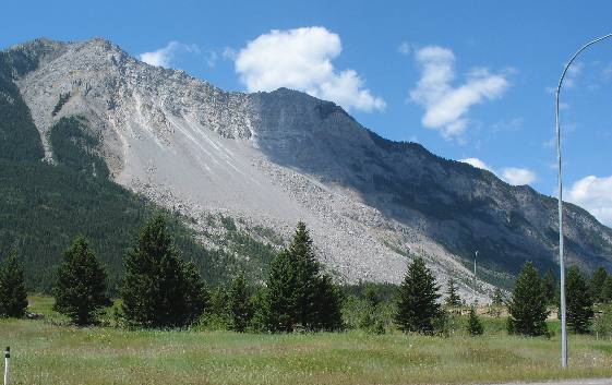
Driving west on PH 3 about 15-miles west
of Pincher Creek Turtle Mountain comes into view with this awesome landslide scar
clearly visible for miles and miles away.
While this landslide clearly
looks awesome from where we are we are only able to see possibly 1/2 of the area
covered by the slide. This scene just prepares visitors for what they are about
to view.
Frank Slide
As
we get closer to the slide on the eastern side we turn off PH 3 and take a "scenic"
drive cut through the slide rubble not far above the river. At this time we have
yet to realize the true magnitude of this slide. At this time we also do not realize
that the slide covered the river and that a path had to be cut allowing the river
to flow or the dam that it created would flood cities upstream and cause a potential
hazard to communities downstream when the dam gave way. So the green area you
see now is the river. At this time we did not realize that a path had been cleared
of debris so the river could once again flow freely. The slide covered the river
with debris for what I would say is a mile or more so the job of clearing rubble
was a major one.
Remnant
of the old mining town of Frank
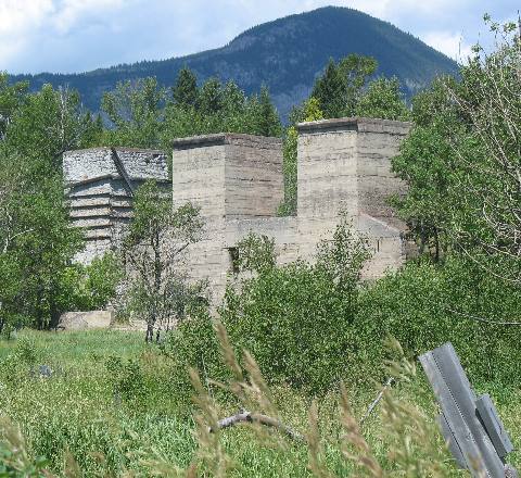
While
driving through the "scenic road" (cut through the rubble) we came upon
this structure that survived the slide. It was one of the few things in the mining
town of Frank to survive. It looks like it might have been the mine entrance but
I am not sure. I am sure that any good story about the Frank Slide would identify
this structure.
It is impossible to comprehend how this one swath survived
when the falling slide rocks parted as they made their way past this structure.
I guess some things are not to be known. This structure sits mid-way through a
mile wide fan of rocks that came tumbling down off the mountain above and went
flying by only to stop possibly a mile up the hill on the other side of the valley.
Frank
Slide
Here
again you can see the river where rubble was cleared to allow it to flow again.
Frank
Slide Monument
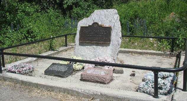
This
is a small monument to those who lost their lives in Frank Slide.
Frank
Slide
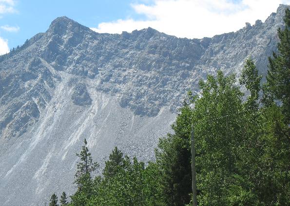
This is a closer look at Turtle Mountain
one of the Front Range Mountains in this area. Note that it is a "classic"
Front Range Mountain with highly tilted bands of grey colored sedimentary rocks
made up of limestones, slates and sandstone.
The part that
broke off and fell creating the Frank
Slide was an enormous portion of the top of that mountain.
Frank
Slide
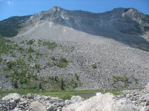
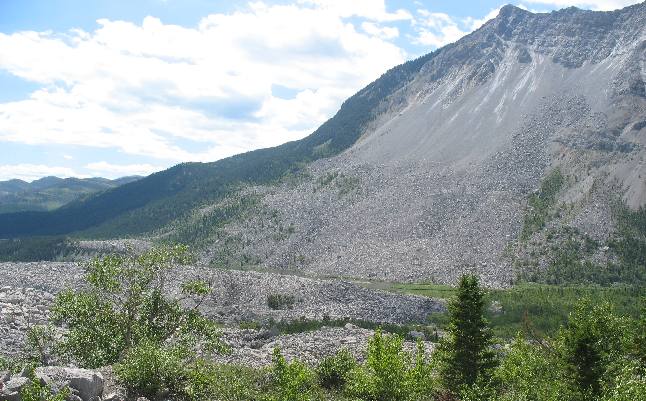
This picture is taken from high on the north
side of the slide looking to the east. Turtle Mountain is on the right and across
the river from where this picture is taken. In otherwords at this point the slide
has crossed the river and is climbing up the other side. What isn't captured in
this picture is where the rocks ended up. At this point I would estimate that
we are at least 1/2 mile from the river and several hundred feet in elevation
above the river.
Frank Slide
debris field
Now,
this picture gives a better perspective of the enormity of Frank Slide. I took
this picture from the Frank Slide Interpretive Center 1/2 mile up the mountain
on the opposite side of the valley and you can clearly see that the slide went
flying past this spot. Between where we are and Turtle Mountain on the other side
lie the river and PH 3. The rock slide through those areas had to be cleared to
make room for both of these to pass through.
The (CPR) Canadian
Pacific Railway snakes along the Crowsnest River valley. This important transportation
route was completed through Crowsnest
Pass in 1898. Mines were soon opened near the railway. Bituminous coal,
(soft coal) which is still abundant here, was good for fuel for steam production
and the mines vied with each other for contracts to supply the railway. The leftover
coal known as "slack", which was too small for any other use, was used
to make "coke", a nearly pure carbon fuel produced by heating coal to
remove impurities. Crowsnest
Pass was close to markets for the coke, such as the smelters at Trail,
British Columbia and in the northwestern United States which refined metal from
ore.
Frank Slide debris field
From
this viewpoint on the opposite side of the valley it is much easier to see how
the debris pile fanned out when it started up the opposite side.
We
are as much as possibly a mile from the center of the slide at this point. Where
the slide crossed the river it may be a mile wide.
From this vantage
point it is difficult if not impossible to imagine that anything in the path of
these rocks could have survived yet the rocks did part to go around that building
in the earlier picture. By the way that building is down near the river near the
center of this picture.
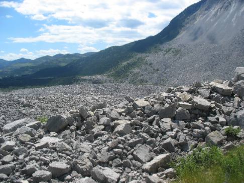
Debris
field from Frank Slide
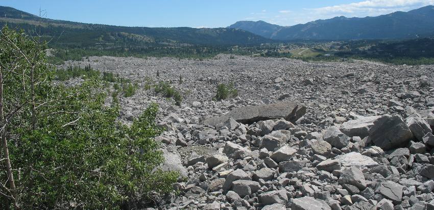
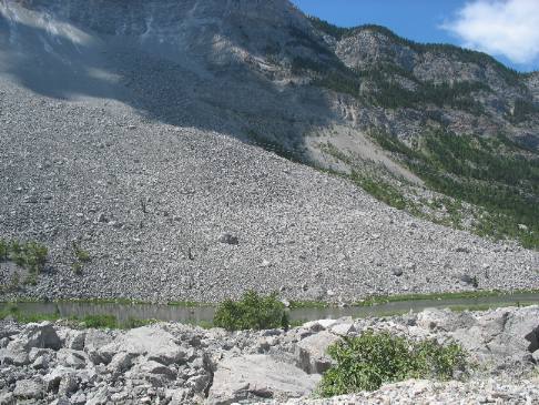
On
April 29, 1903, at 4:10 am, 90 million tons of limestone crashed down from the
summit of Turtle Mountain, burying part of the town of Frank. The rockslide-avalance
devastated 1.2 square miles of the valley in less than 100 seconds. An estimated
70 people were killed.
This picture was taken looking east from the Frank
Slide Interpretive Center high on the opposite side of the Valley from
where these rocks came from. From this view point we are looking at the furthest
reaches of the rock slide. The slide had fanned out at this point.
When
the landslide took place most of the almost 600 residents of the coal mining town
of Frank were asleep. At the coal mine, the night shift was down in the mine,
and a few men were working on the surface in the mine buildings.
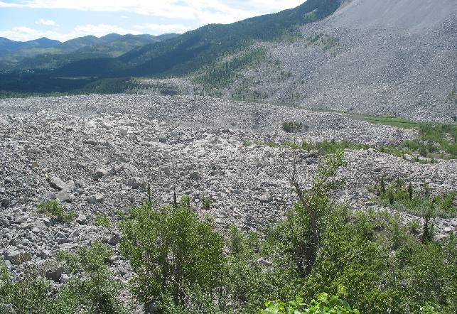
Debris
field from Frank Slide
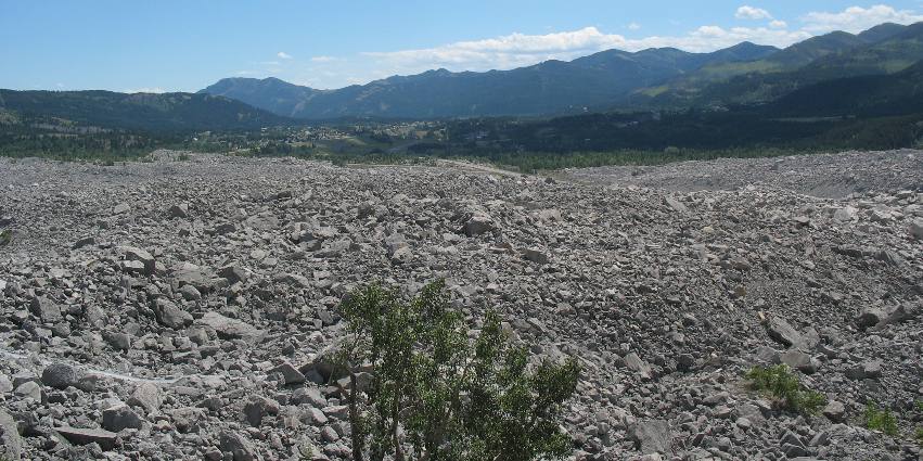
This
is just another view looking down the valley and across the debris field. A huge
wedge of limestone almost a mile wide, at the crest of Turtle Mountain broke off.
It smashed apart as it slid downwards, breaking into boulders that rolled and
bounced down the side of the mountain, and spread across the valley.
In
about 90-seconds, homes, buildings and lives were destroyed. Rocks covered part
of Frank, closed the entrance to the mine, and swept away the mine buildings and
those working in them. Miners trapped underground managed to tunnel their way
to the surface. The slide had also buried a construction camp, livery stables,
tents, a store, and some ranch buildings. 70 people are known to have died.
The
sound of the slide was heard miles away, and clouds of limestone dust hung over
the Pass for quite a while.
Since that day the slide has remained an imposing
presence that will always be with residents of the area.
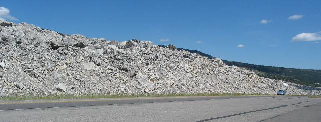
Frank
Slide debris beside PH 3 Crowsnest highway
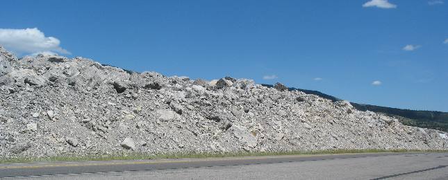
This
picture was taken from PH 3 (Crowsnest Highway) to show how much of the slide
debris had to be removed in order to construct the highway through the slide debris
field.
Debris
removed from the highway
Like
I have stated, the slide covered at least a mile of the valley when it crossed
over this area. One can only imagine the immense job it must have been to clear
the rubble in order to construct this highway.
Frank Slide rubble on the
side of PH 3
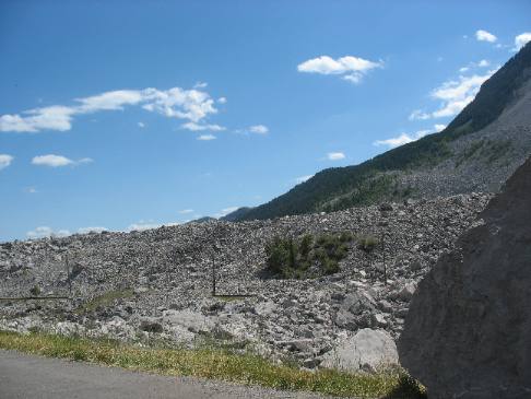
This
picture is again taken from PH 3 but it is looking back toward Turtle Mountain
where the rocks came from.
Frank
Slide debris beside Crowsnest highway PH 3
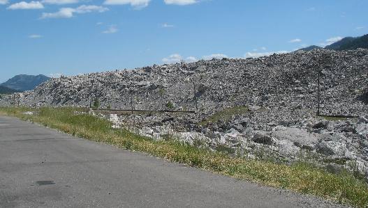
Frank
Slide debris on both sides of PH 3
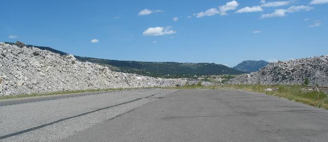
This
picture was taken from PH 3 somewhere inside the debris field looking east.

Mike
& Joyce Hendrix who we are
We
hope you liked this page. If you do you might be interested in some of our other
Travel Adventures:
Mike & Joyce Hendrix's
home page
Travel
Adventures by Year ** Travel
Adventures by State ** Plants **
Marine-Boats ** Geology
** Exciting Drives ** Cute
Signs ** RV
Subjects ** Miscellaneous
Subjects
We
would love to hear from you......just put "info" in the place of "FAKE"
in this address: FAKE@travellogs.us
Until next time remember how good life
is.