South Pass on the Oregon Trail
We stopped for the day in Rock Springs but quickly got in our Saturn and headed to South Pass on the Emigrant Trail. To get to South Pass we had to go north out of Rock Springs for 39-miles through Eden then to Faison where we turned east on SR-28. Parting-of-the-Ways on the Oregon Trail
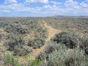
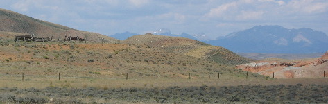
From Faison to South Pass City is another 48-miles. These distances would scare us back east but out here they are nothing. There are no stop lights and very little traffic. Dodging rabbits with death wishes is about all there is to do except enjoy the scenery. We stopped at one Emigrant Trail historic site where we inspected trail ruts. This site was 10-miles east of the infamous "Parting-of-the-Ways" site where emigrant parties separated on their journeys to Oregon, California, or Utah. Where we were is part of the Oregon Trail over which 350,000 to 500,000 people passed on their way West between 1844 & 1869. When we look closely at the ground we can see ridges in the ground, actually trail ruts made by the passage of iron-wheeled freight wagons and stagecoaches on a road that connected South Pass with the Union Pacific Railroad in Green River, to the southwest of where we are. This freight road was used from around 1870 to 1900. In other words this road "freight road" that headed off to Green River was not made until after the decline of the Oregon Trail and after the transcontinental railroad was complete. Never the less we can still see the ruts in this delicate landscape left here over 100-years ago.
South Pass on the Oregon Trail
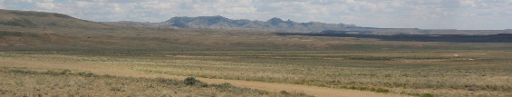
Back in our Saturn the next stop was an interpretive site provided by the US Dept. of the Interior providing a pullout for vehicles and a walkway overlooking South Pass. One would think that crossing over the Continental Divide would be at the peak of a mountain. While South Pass is situated on the Continental Divide is is a 20-mile wide opening in the mountains where travel across the otherwise impassable Rocky Mountains.
South Pass on the Oregon Trail
To understand the significance of South Pass to western emigrations one must understand a little history of the area and that leads us back to the early 1800's when demand for beaver pelts led to the exploration and eventual settlement of the American West. South Pass was part of a major thoroughfare through the Rockies. Its Discovery was significant to the fur trade era. As far as anyone knows South Pass was first crossed by white men in 1812 (Louis and Clark made their famous expedition to the west coast and back between 1803 and 1806 but not through South Pass). The Astorians, a small party of American Fur Company trappers led by Robert Sturart, used South Pass as they traveled east with dispatches for company owner, John Jacob Astor. Even though Stuart noted South Pass in his diary and word of his journey was printed in a Missouri newspaper, it would be another decade before white men "rediscovered" it.
Even after the rediscovery of South Pass in 1824, it was years before the route was used extensively. Fur trapper/trader William Sublette brought a small caravan of wagons to South Pass in 1828. While his party did not take wagons over the pass, they demonstrated the feasibility of using them. Captain Benjamin Bonneville took the first wagons over South Pass in 1832. But it was US Government explorer, Lt. John Fremont, who was responsible for publicizing the South Pass route. Freemont was exploring the far west with Kit Carson as his guide/scout. Scattered references to an easy passage over the Rockies had appeared in newspapers for a decade before 1842 when Fremont created enthusiasm for South Pass by explaining that a traveler could go through South Pass without any "toilsome ascents". As knowledge of South Pass became widespread, a great western migration commenced. Thousands of Mormons and future Orgonians and Californians would use South Pass as their "gate" to lands west over the next 20-years.
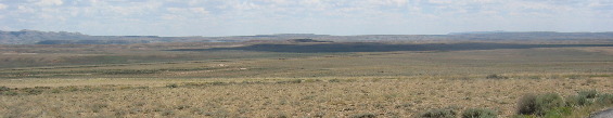
South Pass on Oregon Trail
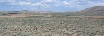
From where these pictures of South Pass are being taken South Pass doesn't look all that remarkable. But --------- and it is a BIG but, compared to the rugged Wind River Mountains, it can easily be recognized as a type of gateway.
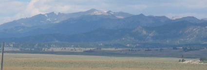
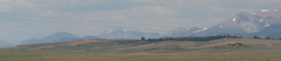
Wind River Mountains in Wyoming
These are the Wind River Mountains that had to be avoided for there was NO WAY to get wagons across them.
Crossing the Continental Divide into "Oregon Country" was a task for all westward-bound travelers, and many described their feelings about the event. In 1852 Lucy Retledge Cooke, a young woman with "California Fever" wrote: "...This morn we arrived at the South Pass after which all water we see will be running to the Pacific. So we are now on the other side of the world..." The trail over South Pass is a corridor which served many purposes. In addition to being the route to Oregon and California, it was used by Mormon pioneers to get to Utah and by the Pony Express. A great exodus to the Salt Lake Valley in 1847 was only the beginning of Mormon emigrant travel along the Oregon Trail. About 68,000 took the Utah branch of the trail from 1847 until 1869 when the completion of the Union Pacific Railroad ushered in a new phase of overland travel. The community of Zion at Salt Lake offered economic opportunity as well as religious freedom.
South Pass on the Oregon Trail
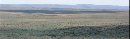
Keep in mind that South Pass is 20-miles wide. Emigrants chose to take the route that entailed climbing the least amount of elevation change. For a brief eighteen months beginning in Aril, 1860, eighty young men carried the nation's mail on horseback for 1,600 miles from St. Joseph, Missouri to Sacramento, California. Riding day and night - regardless of weather, on the fastest horses available, Pony Express riders maintained a vital communication link between east and west at the beginning of the Civil War. The completion of the transcontinental telegraph line in October, 1861 marked the end of the Pony Express. Though the owners of the Express lost more than a million dollars, the venture captured the imagination of the entire world. With South Pass behind them, Oregon and California-bound travelers faced the second half of their journey. The roughest travel was yet to come. From Missouri to South Pass, emigrants were able to follow rivers. But from South Pass to Oregon and California, they faced dry stretches such as the high-altitude desert of the Green River Basin. The dry climate played havoc with wagon wheels that kept shrinking wood away from iron rims. Approximately 20 miles on the trail west of South Pass, emigrants arrived at the Sublette Cutoff, also known as the "Parting-of-the_Ways" that I wrote about earlier. It was there that groups separated, some going to Oregon, some to Utah and others to California. Whatever their destination, every day they struggled with life along the trail. Lonely graves, most unmarked, are testimony to thousands of lives taken by cholera, accidents - especially at river crossings, and childbirth. Attacks by Native Americans were often feared, but almost never occurred. It may be hard to visualize the lives of these people, but a short walk into the landscape allows insight into some of the problems they faced. Wind River Mountains north of South Pass
While standing on South Pass looking north we can see the Wind River Mountains that still have snow on them and it is late July.
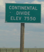
Continental Divide at South Pass on Oregon Trail in southcentral Wyoming
Where the road crosses over the Continental Divide the elevation is 7,550'. Where the emigrants crossed over the Continental Divide a few miles south of the current road the elevation is probably 200' feet less.
Wind River Mountain Range as seen from South Pass |
| ||

| |||
|
| |||