Union Pass between Pinedale and Dubois,
Wyoming
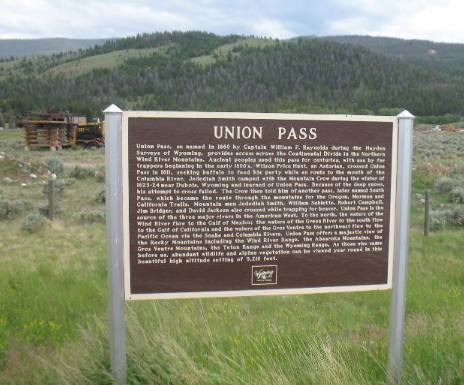
Union Pass is a high mountain pass in the Wind
River Range of western Wyoming
in the United States. The pass is located on the Continental Divide
between the Gros
Ventre Mountains on the west and the Wind
River Range on the east. The pass was historically used by
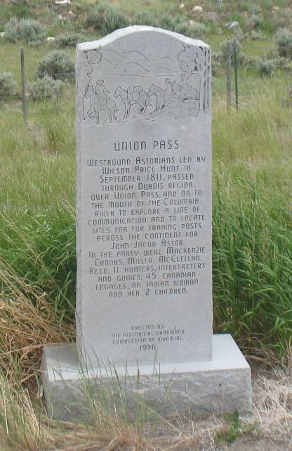
Native Americans and early mountain men including the Astor Expedition
in 1811 on its way west. On the return trip, fearing hostile Indian
activity near Union Pass, the Astorians chose a southern route and
discovered South Pass.
An unimproved dirt road (Union Pass Road) crosses the pass, connecting
U.S. Route 26 near Dubois
to U.S. Route 189 in Pinedale.
Union Pass Marker on US-26 between
Dubois
& Moran
Junction, Wyoming in the Wind
River Mountains
A monument on top marks the transition on the Continental Divide from the Wind
River drainage to the Green River drainage. However, the same
area also marks the transition to the Snake River drainage making
this place the headwaters of the three major river systems (Green/Colorado,
Snake/Columbia, and Wind River/Missouri) of the western United States.
The central location and relatively easy transitions from any of the
three drainages to the others has made it an important spot thousands
of years. Besides some roads, the area is probably much the way it
has been for hundreds of years.
Union Pass
At Union Pass a maze of mountain ranges and water courses which had
sometimes baffled and repulsed them-aboriginal hunters, mountain men,
fur traders and far-ranging explorers have, each in his time, found
the key to a geographic conundrum. For them that conundrum had been
a far more perplexing problem than such an ordinary task as negotiating
the crossing, however torturous, of an unexplored pass occurring along
the uncomplicated divide of an unconnected mountain chain.
Hereabouts the Continental Divide is a tricky, triple phenomenon
wherein the unguided seeker of a crossing might find the right approach
and still arrive at the wrong ending. In North America there are seven
river systems that can be cited as truly continental in scope but
only in this vicinity and at one other place do as many as three of
them head against a common divide. Indians called this region the
Land of Many Rivers and mountain men named the pass Union, thereby
both—once again-proving themselves gifted practitioners of nomenclature.
Union Pass is surrounded by an extensive, rolling, mountain-top terrain
wherein elevations vary between nine and ten thousand feet and interspersed
water courses deceptively twist and turn as if undetermined betwixt
an Atlantic or a Pacific destination. This mountain expanse might
be visualized as a rounded hub in the center of which, like an axle’s
spindle, fits the pass. Out from this hub radiate three spokes, each
one climbing and broadening into mighty mountain ranges-southeasterly
the Wind Rivers, southwesterly the Gros Ventres and northerly, extending
far into Montana, the Absarokas.
The Rendezvous
Twelve thousand foot mountain plateaus dominating this view of Green
River and Snake River headwaters seemingly provide a southwesterly
buttress for loftier peaks forming the core of the Wind
River Range. Beyond them it is 43 miles from Union Pass to
where confluence of the Green and its Horse Creek tributary marks
the most famed of several “rendezvous” grounds relating
to that epoch in American history known as the Rocky Mountain Fur
Trade.
“Rendezvous”, defined as a trade fair in wilderness surroundings,
was held in diverse locations throughout the Central Rocky Mountain
region. It required spacious, grassy environs for grazing thousands
of horses, raising hundreds of trapper and Indian lodges and for horse
races and other spectacles exuberantly staged by mountain men and
Indians then relaxed from vigilance against dangers which otherwise
permitted no unguarded carrousels. A favorite area for “rendezvous”
was along the Green, recognized for producing the primest beaver peltry,
and for conveniently straddling the South Pass logistic route utilized
for transport of trade goods and furs between St. Louis and the mountains.
On the Green the finest “rendezvous” grounds—rendered
especially famous through Alfred Jacob Miller’s paintings of
the 1837 scene—were those at Horse Creek.
Depending on arrival of St. Louis supply caravans, ‘rendezvous”
usually extended through early July. At the close of revels—leaving
many mountain men deeply in debt—there remained up to two months
before prime furs signaled the start of fall hunting. The intervening
time was pleasantly occupied in traveling and exploring high mountain
terrain; then trails around Union Pass were furrowed by Indian travois
only to be leveled again by the beating hoofs of the trapper’s
pack trains.
Three Waters Mountain
Southeast rises a mountain given a lyrical name, one such as Indians
or mountain men discovering a geographical phenomenon might have chosen.
Midway of its four-mile long crest is the key point, one of only two
in North America, where as many as three of the continents seven major
watersheds interlock.
Here a raindrop splits into thirds, the three tiny driblets destined
to wend their separate ways along continuously diverging channels
to the oceans of the world. One driblet arrives in the Gulf of Mexico,
3,000 miles distant by way of Jakeys Fork, Wind River, Bighorn, Yellowstone,
Missouri, and Mississippi; another joins currents running 1,400 miles
to the Pacific through Fish Creek, the Gros
Ventre, Snake
and Columbia; the final one descends more than 1,300 miles to the
Gulf of California; via Roaring Fork, Green River and the Colorado.
In 1807-1808 John Coulter explored the area now known as Union Pass
on his way to Yellowstone. He was the first white man known to cross
the pass. In 1860 Captain William F. Reynolds' part of the US topographical
Engineers named the crossing as Union Pass.
The
Dubois-Union
Pass Corridor is one segment of a three-pronged complex of historic
trails that converge in the area of Union Pass from Pinedale,
Jackson
and
Dubois
regions. Union Pass is a National Forest Register Historic Place on
the Continental Divide and is located at the northwest end of the
Wind
River Mountain Range in northwestern
Wyoming.
The pass is at an elevation of 9210 feet.
Three different mountain ranges rise in the distance to heights of
13,000 feet or more. They are the Wind River and Gross Ventre Ranges
to the southwest and the Absaroka Range to the north. The main mountain
passes visible from the pass are Union Peak to the east, Triple Divide
Peak to the southeast, rims of the Roaring Fork Plateau to the south
and parts of Ram's Horn to the north.
Elevation: 9,210 Feet
Distance: 15 Miles
Directions: From Dubois,
Union Pass Road is accessible by traveling nine miles northwest Dubois
on US 26-287 to the marked Union Pass. Follow Union Pass road 15 miles
to an interpretive site complete with a short nature walk that explains
in part the surrounding area.
Until next time remember how good life is.
Mike & Joyce
Hendrix

Mike
& Joyce Hendrix who we are
We hope you liked this page. If you do you might be interested in
some of our other Travel Adventures:
Mike & Joyce Hendrix's home
page
Home
** Travel
Adventures by Year ** Travel
Adventures by State
**
Plants ** Marine-Boats
** Geology **
Exciting Drives ** Cute
Signs
** RV
Subjects ** Miscellaneous
Subjects
We would love to hear from you......just put "info" in
the place of "FAKE" in this address: FAKE@travellogs.us
Until next time remember how good life is.