Soldier Summit on U.S. 6May 25, 2007. We are staying at Lakeside RV-Park on west Center Street in Provo (next door to Utah Lake State Park located on Utah Lake). We forgot all about Memorial Day until late last week when "the lights came on". Joyce immediately got on the cell-phone and started trying to locate a place for us to settle in for the long Memorial Day weekend. She got lucky and found the last vacancy at Lakeside RV-Park. That is why we are here but we are happy to be here. It is a nice park costing 27.41 per-night for FHU and plenty of shade from mature cottonwood trees. Down the street is Utah Lake State Park where rates are $18 per-night for water & electric and central dump station. They were full or we would have probably been there. Either would be just fine, in our opinion, although Lakeside RV is much nicer and overflows with more expensive RV's -- if you get my drift.
Passport America - Discount
Camping Club We overnighted in the Wal Mart parking lot in Price, Utah last night then got back on U.S. 6 and continued on our way to Provo, 75 miles away. We noticed that we were climbing when we left Price. I can't remember how long we climbed but I remember seeing an elevation sign that said "Elevation 7,700" at the time we commented on the elevation sign but did not understand why it was there. We should have known --- we were on Soldier Summit. Shortly we knew why the elevation sign was there. We started seeing road signs warning of a steep grade ahead. Those signs are something that RV'ers pay attention to. Anyway, we are on top of what turns out to be a tremendous grade. We started dropping at that sign and didn't stop dropping until we exited on I-15 some 35-miles away. I can't think of any grade that we have been on that stretched out for so long, it just went on and on while we dropped 3,000 feel in elevation. This is part one of a four-part series of travel logs covering the down hill grade from Price to Provo, Utah on US-6: The other travel logs in this series are here: Soldier Summit ** US-6 Price to Provo ** Steep grade on US-6 ** Price to Provo on US-6
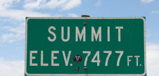
Soldier Summit 35-miles east of Provo, Utah on US-6
Soldier Summit has been an important spot on the transportation route between the Wasatch Front (the Salt Lake City Valley) and Price, Utah, since the area was settled by the Mormon pioneers. We all know that native American Indians used this route before Mormon pioneers arrived, they just did not leave a written history. Let me put this into perspective for you. Soldier Summit is the easiest way for those in the "valley" around the Great Salt Lake (elevation 4,200') to travel east toward Price, Utah and Green River, Utah and other places to the east like Grand Junction, Colorado. While the valley around Provo, Utah is 35-miles west of Soldier Summit you can see that there is a 3,000-foot plus drop in elevation. Let that sink in for a moment. If you are traveling east or west on US-6 between Price and Provo, Utah you are going to be using a lower gear to climb that 3,000 feet or you are going to be using a lower gear to control your speed on the way down that grade.
Soldier Summit 35-miles east of Provo, Utah on US-6
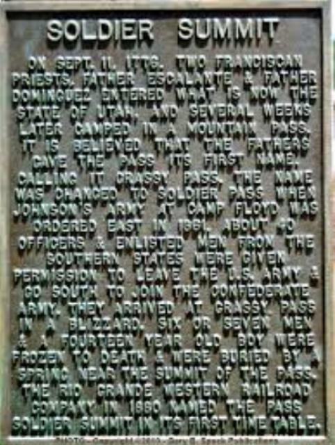
Take time to read this plaque from Soldier Summit. One piece of history that I found "odd" was the part about Johnson's Army at Camp Floyd was ordered ease in 1861. About 40 officers and enlisted men from the southern states were given permission to leave the US Army & go south to join the Confederate Army. They arrived at what was then "Grassy Pass" in a blizzard. Six or seven men & a 14-year old boy were frozen to death. And now you know why Soldier Summit is now Soldier Summit instead of Grassy Pass.
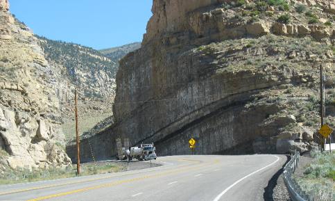
Uplifted sedimentary rocks on US-6
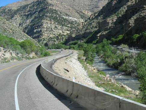
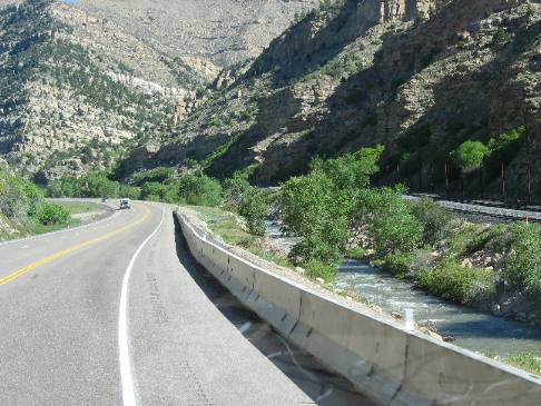
US-6 is dropping 3,000 feet in elevation between Soldier Summit and Provo in the Salt Lake Valley.
Grade on US-6 heading into Provo, Utah
It wasn't a particularly steep grade. I would estimate most of it was 2% to 4% with some stretches at 5%. In many places we are able to see RR tracks beside the road. RR beds are generally limited to 2% grades so I was using that 2% rule as an estimating tool.
As we are falling down the grade my transmission is able to hold our speed to 55 mph most of the time without me applying brakes. I certainly didn't need to provide any fuel to fall off Soldier Summit.
I am interested in the geology as roadcuts expose layer upon layer of sedimentary rock. As we fall off the summit rock layers become older and older.
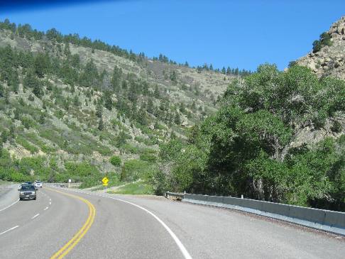
Grade on US-6 heading into Provo, Utah
Relentlessly the grade continues.
Grade on US-6 heading into Provo, Utah
The layers of sedimentary rock change as we cut deeper and deeper into the earth's crust.
This is part one of a four-part series of travel logs covering the down hill grade from Price to Provo, Utah on US-6: The other travel logs in this series are here: Soldier Summit ** US-6 Price to Provo ** Steep grade on US-6 ** Price to Provo on US-6 Until next time remember how good life is. Click here for more Utah travellogs
More Utah AdventuresSome Key West Adventures ** More 2007 Travel Adventures
Mike & Joyce Hendrix
Mike & Joyce Hendrix who we are We hope you liked this page. If you do you might be interested in some of our other Travel Adventures: Mike & Joyce Hendrix's home page Travel Adventures by Year ** Travel Adventures by State ** Plants ** Marine-Boats ** Geology ** Exciting Drives ** Cute Signs ** RV Subjects ** Miscellaneous Subjects
We would love to hear from you......just put "info" in the place of "FAKE" in this address: FAKE@travellogs.us Until next time remember how good life is.
|
| ||
|
| |||
|
| |||
|
|