John Wesley Powell Museum in Green River, UtahWe
stopped in Green River, Utah to visit the John Wesley Powell Musuem. We left Fruita,
(Grand
Junction) Colorado this morning on our way to Price, Utah where we plan
to spend the night. After visiting "The John Wesley Powell Museum" we
took US-6 from Green River to Price, Utah where we stopped for the night. May 24, 2007. We overnighted in the Super Wal Mart parking lot in Price.
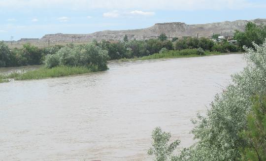
Green River in Green River, Utah
We stopped for a few hours at the John Wesley Powell River History Museum in Green River, Utah. The town of Green River, Utah is located at a centuries old crossing of the Green River. It was settled in the late 1870's as a mail relay station. Today tourism and melon growing dominate Green Rivers economy. It was a great museum covering not only Powell's epic journey down the Green and Colorado Rivers but also much of the early history of this area.
Speaking of the Green River------ the Museum is appropriately situated on the south bank of the Green River in the town of Green River, Utah. (Do not confuse Green River, Utah with Green River, Wyoming) While both towns are situated on the Green River you will find Green River, Wyoming on I-80 and Green River, Utah on I-70. Around 200 miles of rugged, inhospitable landscape separates the two. Ancient inhabitants of this region found formidable obstacles to migration and trading in the deep canyons and gorges of the Green River. In hundreds of miles of canyonlands, the shallow and placid waters near this site provide the only convenient crossing of the otherwise swift and moody river. In their turn, every group of people attempting to traverse this region or settle in it has encountered the same difficulties. The routes of Spanish missionaries, Mexican traders, white explorers, pioneers, railroads and superhighways have all converged on this same point in the river that we now know as Green River, Utah. Permanent settlers did not arrive in the Green River, Utah area until 1878, due to its arid climate and relative isolation. As their numbers increased, the need also grew for more convenient transportation from one side of the river to the other. By 1880 at least one commercial ferry was in operation on the river. Eventually, several other family-owned ferries were also in use. In 1883 the Denver & Rio Grande Western Railroad completed its route from Denver to San Diego, including a steel bridge to span the Green River. Unfortunately for local commerce and residents, the railroad bridge accommodated no other modes of transportation. As horses and wagons gave way to the automobile, plans were developed for a pedestrian and highway bridge to span the river. In 1911, those plans were realized with the completion of the first Green River Bridge. To begin with, as in 2,000 years ago, the Anasazi and Fremont cultures managed to thrive in what is now Southern Utah. Much later the Navajo, Ute and Paiute Indians settled in various parts of the state. In 1776 a hardy group, led by Franciscan Priests named Dominguez and Escalante, explored much of the Utah region, and gave the rest of the world its first written description of the area. Just to make sure that you don't just breeze over that 1776 date that these Priests were exploring Utah --- keep in mind that 1776 is when the Declaration of Independence was happening back in eastern North America. Then in the early 1800's mountain men marked and mapped the routes that later would be followed by pioneers. The Lewis & Clark Expedition was in 1804 to keep this in perspective. Mountain Men came on the heals of the Lewis and Clark Expedition. Mormons were the first permanent non-Native American settlers in Utah, entering the Salt Lake Valley for the first time on July 24th, 1847. But before we get too far into this history lesson let's try and put things in perspective. The first Europeans to come in contact with the Colorado River were Spanish Conquistadors. Less than fifty years after Columbus' discovery of America, and only 20 years after the defeat of the Aztecs, these Spanish warriors had discovered the Colorado River's mouth and had gazed awestruck into the depths of the Grand Canyon. Though Spain never sent more than a handful of explorers into the Colorado River country; these few left a pronounced and enduring impression. In early 1540 Conquistador Francisco Vasquez de Coronado traveled overland from Northern Mexico. A small contingent of his group commanded by Lopez de Cardenas, ascended a pine covered plateau where, they were confronted by a gorge they could not describe in words. They had discovered the Grand Canyon of the Colorado River. Following closely and sometimes even accompanying the Conquistadors were priests who came to convert the Native American peoples to Christianity. From 1604 until the end of the 18th Century, this land belonged to the Padres. In 1604, Don Juan de Onate, governor of New Mexico, led a group of Padres and soldiers westward from the Rio Grande into present-day Arizona, seeking to reach the Pacific Ocean. After several weeks, they reached a muddy, red-colored river Onate called "Colorado" or "red". It was not the actual Colorado but its tributary, the Little Colorado, but it marked the first use of the name. During the late 18th and early 19th Centuries, a fashion craze developed some 7,000 miles east of the Rocky Mountains that would affect the Colorado River area as few events had before. The dandies of western Europe had discovered the beaver hat, and to meet the demand had trapped and depleted the European and even the eastern American beaver populations. By the 1820s enterprising trappers were turning envious eyes to the Great American West and its untapped supply of beaver. In the search for pelts, mountain men penetrated virtually all areas of the west, including the canyons of the Green and Colorado Rivers.
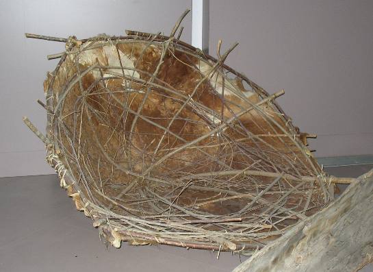
Bull boat
William Ashley was another individual that played a large role in the early history of this region. Born in Virginia, Ashley moved to Missouri, and entered into a venture which eventually became one of the most significant fur trade companies in the west. In 1825, he led a group of fur trappers to the upper Green River where Ashley decided to combine trapping with exploring. After building bullboats by stretching buffalo hides over willow frames, he embarked on the first known attempt, by whites, to navigate the Green River.
Yes, that is a bullboat like the one William Ashley attempted to float down the Green River on.
In Red Canyon, where the group stopped to carry their boats and gear past a rapid, Ashley inscribed "Ashley 1825" on a rock in large black letters. This inscription was noted by Powell's party 44 years later. In Split Mountain Canyon, Ashley nearly drowned when his boat swamped, with only quick action by his men saving his life. When William Ashley and his trappers decided to try the river as a means of travel in 1825, they utilized the same craft they had used to transport pelts on other streams--------bulboats. Made of buffalo hide stretched over a framework of willows cut from the riverbank, bullboats were easily fabricated and could carry large loads, but were difficult to navigate and not well-suited to travel on a major river. In spite of the bullboats' limitations, Ashley and his men were able to float more than 200 miles down the Green, before being convinced to leave the river by Indians. Although Ashley was the "first" other trappers "mountain men" soon followed. Between 1831 and 1838, a trapper named Denis Julien worked the canyons of the Green from the Uinta Basin to the confluence of the Green and Colorado, possibly utilizing a boat. Then in 1849, William Manley, leading a group of California-bound "49'ers", almost duplicated Ashley's voyage 24 years earlier. These early efforts demonstrated the difficulty of trying to use the river as a means of transportation. It would be another twenty years before anyone would successfully navigate the river through the often treacherous canyons below the Unita Basin.
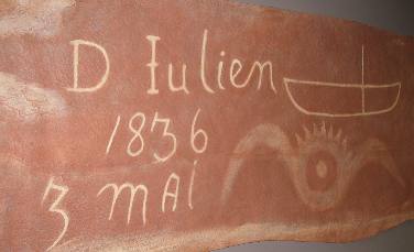
Denis Julien
Like many mountain men, Denis Julien left no memoirs, so little is known of him. He was apparently of French descent and probably worked for one of the Robidoux brothers, trappers out of Taos, New Mexico. Like Ashley, he left inscriptions in canyons, so his travel can be traced to some extent. In 1831 he was near Whiterocks on the Uinta River below Vernal, and in 1836 he was down river in Labyrinth and Cataract Canyons near the confluence of the Colorado and Green Rivers. By 1838 he was back up the Green River in Whirlpool Canyon.
James Pierson Beckwourth 1798-1866 was one of those mountain men. An adept and controversial mountain man, Beckwourth was an African American and former slave who was born in Virginia. He joined an expedition of the Rocky Mountain Fur Company in 1823. He became a skilled fur trapper, hunter, and trader, associating with the likes of Jim Bridger and Jedediah Smith. In 1828, he was captured and then adopted by the Crow Indian tribe, earning the title of "war chief". He was a founder of Pueblo, Colorado, a soldier in the U.S. Army, chief scout for Gen. John C. Fremont, and one of the hardy participants in the exploration of the west. I was interested in this Beckwourth fellow when I read this information about him being ---- "chief scout for Gen. John C. Fremont" since on many of Freemont's expeditions Kit Carson was his chief scout. I do know that Kit Carson did not accompany Fremont on all of his expeditions so those must be the expeditions that Beckwourth was associated with or possibly Beckwourth and Kit Carson both accompanied Fremont. Does anyone know which Fremont expeditions Kit Carson was on and which Beckwourth accompanied him? William Manly was one of the most venturesome characters on the river. A Vermont-born Yankee trapper, Manley headed for California in the Gold Rush of 1849. Upon reaching the Green River in Wyoming, Manly and his companions looked at the easy-flowing stream before them and thought if they had a boat, they could simply float to California. Manly and his followers discovered an abandoned ferry boat along the Green River in Wyoming. The group repaired it and cast off. In Red Canyon their craft became wedged on a rock and could not be dislodged.
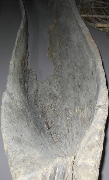
Dugout used on the Green River
The resourceful Manley spied some tall pine trees which he and the men felled and hollowed out. Lashing their pine dugouts together, they continued down the river, swamping several times, losing guns and camping gear.
Today we call these things dug out canoes and they work fine on calm bodies of water but can you imagine trying to ride one of these things down a class 5 rapid? Not in this lifetime.
Upon reaching the Uinta Basin, they met Wakara, a Ute Indian war chief, who advised them strongly against continuing down the river. Manly agreed, although two of his party chose to remain with the river. They only went on to Desolation Canyon, where they, too, decided that they had had enough. Manly went on to California via Death Valley where he and his group suffered terribly before finally arriving at the gold fields. Despite the activity of the fur traders, the Colorado River country remained relatively untouched after fashion whims in Europe ended the fur trade as quickly as it began. In the 1840s and 1850s Mormon settlement and increasing activity by the U.S. Army Corps of Topographical Engineers further expanded the knowledge of the intermountain west. Even so, the Colorado River region was still labeled "unexplored" on maps of the day. "The region...is, of course, altogether valueless. Ours has been the first and will undoubtedly be the last, party of whites to visit the locality. It seems intended by nature that the Colorado River along the greater portion of its lonely and majestic way, shall be forever unvisited and undisturbed." ---- Lt. Joseph C. Ives, 1858 That statement by Lt. Joseph C. Ives, in 1858 pretty much sums up what the early U.S. Army Corps of Topographical Engineers thought about the area. However, the growing Mormon presence saw civilization spread into the Colorado River country but the torturous terrain and unpredictable precipitation limited settlement in the immediate region. At the conclusion of the Civil War, the U.S. Government turned its attention to the vast interior West. Four geographical and geological surveys, called the "Great Surveys", were undertaken between 1867 and 1897 to observe, analyze and map what lay beyond the hundredth meridian. Each survey was given a designated geographical area of responsibility. In 1859, Capt. John N. Macomb led an expedition out of New Mexico that visited the confluence of the Green and Colorado Rivers. Macomb noted: "I cannot conceive of a more worthless and impracticable region than the one we now find ourselves in." Doesn't this sound remarkably similar to the assessment of Lt. Ives in 1858? But wait a minute, things are about to change. An impatient, ambitious and strong-willed, ex-Civil War Veteran was about to do what no one else before him had done and that was to navigate the Green and Colorado Rivers from Green River, Wyoming to the mouth of the Virgin River in Nevada. The year is 1869. Many have tried but all have failed. Besides successfully navigating the river, he explored and mapped the area, named many of its features and identified the basic outlines of the region's natural history. He actually opened up the river to later travel, explorations and surveys by his accomplishment. A professor of geology at Illinois Wesleyan University, Powell had as a primary objective of his river expeditions to obtain information on the geology of the Colorado River region. His observations on the trips and subsequent contributions to the understanding of the region's geology were impressive, especially those relating to the development of the land forms on the Colorado Plateau. His geologic observations and concepts were published in several reports and were later built upon by other prominent geologists to define the major geologic features of the area. Powell was born in Mount Morris, New York, on March 24, 1834. Powell's schooling was informal and irregular. Through tutoring and field experience with an Ohio scientist, he learned the basics of geology, archaeology and biology. In 1851, (he was 17 years old) Powell left home to teach school, something he would do for the next ten years. At a variety of schools, colleges and universities in Wisconsin and Illinois. Part of his activities included boating on the Illinois and Mississippi Rivers to collect shell and fossil samples, exercises that would prove valuable in his later explorations of the Colorado. On November 28, 1861, six months after joining the infantry, a result of the outbreak of the Civil War, Powell married his first cousin, Emma Dean, who would accompany him in many of his western travels.
The stage is now set for one of the best and most significant adventures of all time.
With the conclusion of the Civil War, the development of the "West" began in earnest as first miners, then stockmen, farmers and lumbermen headed into those vast areas as yet untouched. It was time to fill in those blanks on the map that had bedeviled explorers and mapmakers for centuries. In June 1867, a one-armed veteran of the Battle of Shiloh named John Wesley Powell and his wife, Emma Dean, came to t he Rocky Mountains. As curator of a natural history museum in Illinois, Powell had come to augment the museum's collections. His influence on the West would go far beyond collecting a few rock samples for a small midwest museum. Not long after arriving in the Rockies, Powell became fascinated with the idea of exploring the Grand Canyon and was determined to be the first to do it by river. He subsequently split his time between field trips in Colorado, securing government and private appropriations to make the voyages, and making physical preparations for the river trip. Scarcely two years later, by the spring of 1869, Powell had overcome Federal bureaucracy, overseen the construction of his boats and assembled a crew to man them. In early May, Powell arrived by rail with his boats in Green River, Wyoming. (Don't confuse Green River, Wyoming with Green River, Utah) His crew was waiting on him there. The time had come, Powell was ready to embark on his great adventure that would forever change this region. It was May 24, 1869, two weeks after the driving of the golden spike on the transcontinental railroad at Promontory, Utah, that Powell and his men cast off from the river bank in Green River, Wyoming. With him were nine men, mostly war veterans and mountain men, in four boats. The early going was relatively easy and spirits were high. However, after successfully negotiating the roaring waters of Red Canyon and noting Ashley's 1825 inscription at Ashley Falls, disaster struck in Canyon of Lodore. One of the boats hit a boulder and broke up, sending one-third of the expedition's food and half of the cooking gear to the bottom of the river. Fortunately, the crew was rescued and they continued in the remaining three boats. A week later, sparks from their campfire ignited nearby bushes, starting a forest fire that forced the men to run for their lives, causing the loss of most of the rest of the mess kit. In spite of these problems and many others, Powell made scientific observations throughout the trip of the landforms they passed, stopping often to take side trips to gather more information. However, the voyage was damp and arduous, with the men often being forced to carry their boats and all of their provisions past extremely difficult rapids. On July 13, the three boats emerged from Gray Canyon into the valley of present-day Green River, Utah. Continuing on with dwindling rations and deteriorating boats and spirits, they eventually reached the Grand Canyon on August 5. Less than a month later on August 28, after several disputes with Powell, three crew members decided to leave the expedition and hike out. They were killed a few days later by Indians. The remainder of the crew continued on the river and two days later reached the mouth of the Virgin River, finding a group of Mormons who provided them with food. Powell decided to abandon the voyage at that point, although some of the crew decided to carry on several hundred more miles to Ft. Mojave. As the nation learned of his exploits on the waters of the Colorado, he became a national hero. His successes also led to his Congressional appointment as leader of one of the great surveys of the American West, a task he completed during his 1871-2 expedition that involved another trip down the Green and Colorado Rivers. Before the first expedition was completed, Powell knew he would have to make a second trip. The first expedition had, in the end, become a race for survival, resulting in faulty mapping and altitude observations. This second journey was much better planned, financed and organized. Congress appropriated $10,000 for new boats and supplies. Extra supplies were cached at strategic locations along the route to prevent problems experienced in 1869. Whereas the first expedition was primarily exploratory, the second would be more scientific. A photographer and a geographer were included in the crew to aid in the documentation and research of the trip. By spring 1871, all was ready when Powell returned west to begin his second voyage down the river. Although the time Powell actually spent exploring was largely limited to his two river expeditions, John Wesley Powell is probably best remembered as an explorer of the Colorado River area. His exploring career grew out of that field trip to the Rockies in 1867 to study the region's geology and gather specimens for that Natural History Museum in Illinois, where he was curator. As a result of Powell's lobbying, the Federal Government created the U.S. Geological Survey in 1879, and in 1881 he was named director of that survey, a post he held until 1894.
Passport America - Discount
Camping Club These are some of our other Travel Logs in this area: Traveling on I-70 in eastern Utah Arches NP-a ** Arches NP-b ** Arches NP-c ** Arches NP-d ** Arches NP-e ** Arches NP-f ** Arches NP-g Scenic Drive through Sandstone Cliffs ** Scenic Drive along Colorado River ** Scenic Drive through Canyon ** Historic Dewey Bridge Fruita, Colorado ** Scenic Drive along Potash Road in Moab ** Scenic Drive through Colorado River Canyon ** The John Wesley Powell Museum in Green River, Utah Sandstone Cliffs of Colorado National Monument ** Wingate Sandstone of Colorado National Monument ** Kayenta Caprock in Colorado National Monument Sandstone Tunnels in Colorado National Monument ** Fault in Colorado National Monument ** Grand Junction & Fruita, Colorado ** Volcanic Ash of Colorado NM Driving US-191 from Blanding to Moab, Utah ** Geology along US-191 south of Moab, Utah ** Moab, Utah visitor center flowers Until next time remember how good life is. Click here for more Utah travellogs
More Utah AdventuresSome Key West Adventures ** More 2007 Travel Adventures
Mike & Joyce Hendrix
Mike & Joyce Hendrix who we are We hope you liked this page. If you do you might be interested in some of our other Travel Adventures: Mike & Joyce Hendrix's home page Travel Adventures by Year ** Travel Adventures by State ** Plants ** Marine-Boats ** Geology ** Exciting Drives ** Cute Signs ** RV Subjects ** Miscellaneous Subjects
We would love to hear from you......just put "info" in the place of "FAKE" in this address: FAKE@travellogs.us Until next time remember how good life is.
|
| ||
|
| |||
|
| |||
|
|