Places Visited: Montana: Fort Benton July 21, 2007. We are staying in Dick's RV Park in Great Falls, Montana. It is a nice enough park with paved FHU sites & Cable for $27. They do charge extra for wifi but we found an open wifi signal in the park. There isn't a lot of choice in Great Falls, it is either Dick's or KOA and we avoid KOA if at all possible. Bottom line, we would recommend Dick's when stopping in Great Falls.
While our motorhome is located in Great Falls we headed to Fort Benton in our Saturn today. Fort Benton is located about 40-miles northeast of Great Falls. As we are driving US 87 from Great Falls to Fort Benton we are passing through a major grain growing area. Grains like barley, spring wheat and winter wheat seem to be the crop of choice. Very little irrigation is used. Virtually all grain grown in this area is dry farming where the farmer depends on existing moisture and rain.
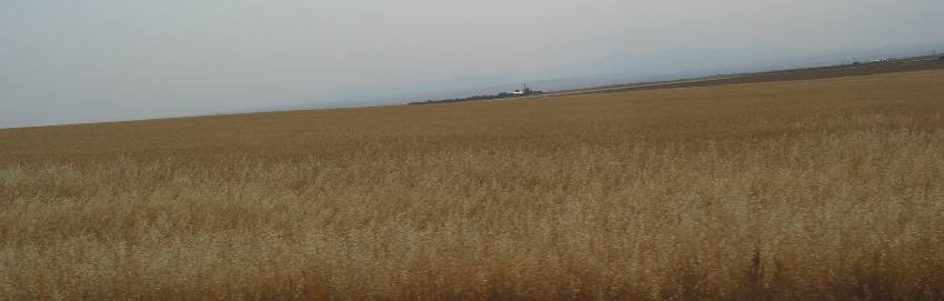
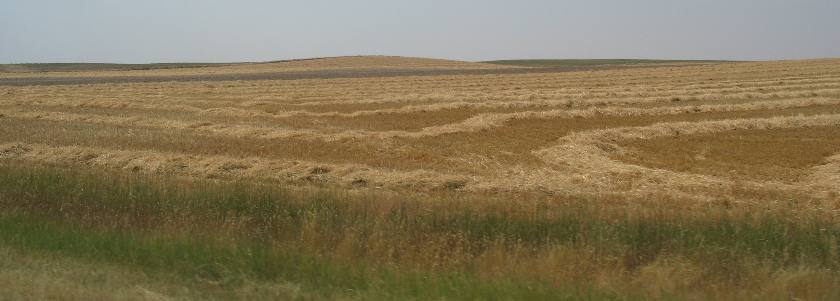
This is typical scenery in northern Montana. Grain fields to the horizon.
Across this "dry-farming" area land is rested between crops. This land is resting. Farmers tell us that because the area is so arid that letting the land "rest" gives it time to replenish much needed moisture in an area that only receives around 14" of moisture each year.
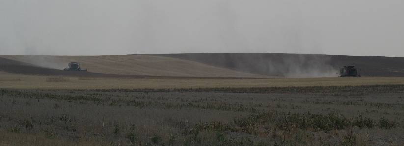
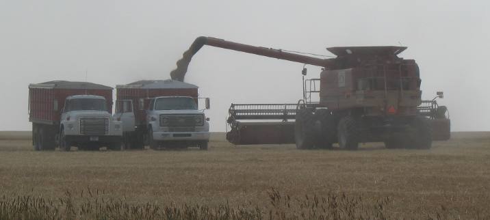
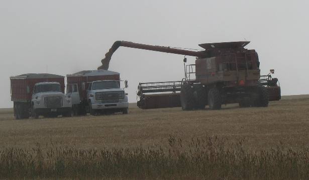
Harvesters arrived in this area earlier in the week. The RV Park we are in has several crews and the RV-Park in Fort Benton had several harvesting crews. As we are traveling to Fort Benton we passed 3 or 4 harvesting crews hard at work.
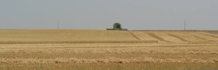
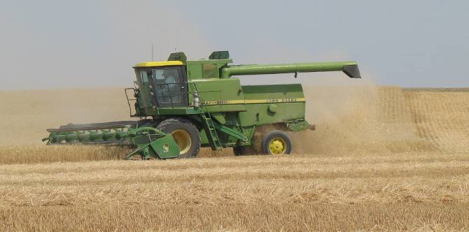
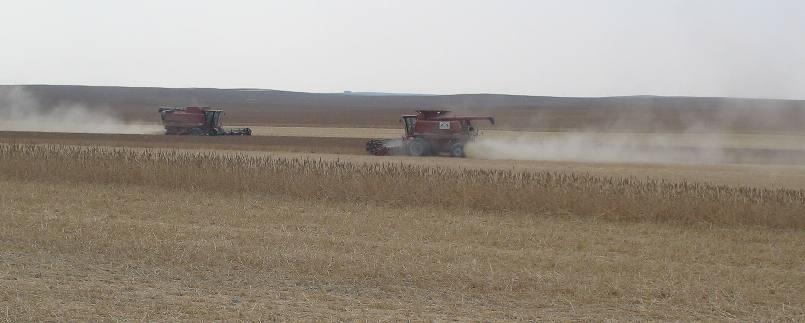
This combine is mowing and processing a wide swath of grain as it lumbers toward us.
Relentless is the way I would describe the way these combines attack a field of grain. They are continually on the move.
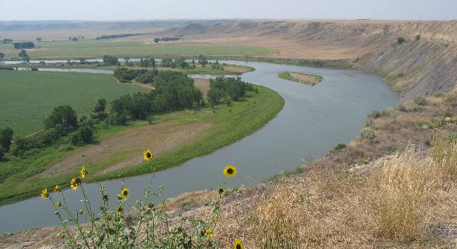
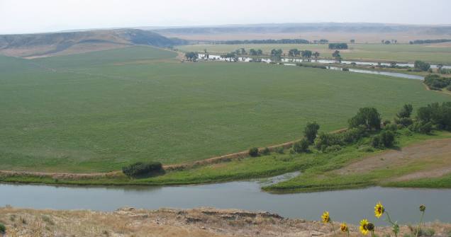
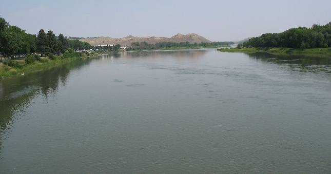
We stopped at a roadside viewpoint that overlooked the Missouri River several miles west of Fort Benton. Locals refer to this as "bottom-land".
A variety of crops, other than grain, are grown on this well watered bottom land. The bottom land in this picture is historically connected to the Lewis and Clark expedition. You already know that the Missouri River in this picture was the path that Lewis and Clark used as their route to the Rocky Mountains. Maria's River enters the Missouri fifteen miles down stream. In June of 1805 the Corps of Discovery spent ten days exploring both forks, trying to decide which way led to the mountains. Although their men wanted to continue up the north fork, (Maria's River) Lewis and Clark chose the south fork. Their decision prevented weeks of retracing the trail and probably saved the expedition. The Corps of Discovery was able to cross the Rockies before winter prevented its passage. When Lewis and Clark found this land of mountains, river valleys and plains, it was so full of buffalo and other grazing animals that it seemed like Paradise. It the 1880's the area became vast open cattle ranges, and today is Montana's greatest wheat producer. The bottom land in this picture was once the site of two fur posts, constructed within a few hundred yards of each other. Fort Cotton was built in 1842 by the Union Fur Company, but existed only two years before it was abandoned. Fort Lewis was owned by the American Fur Company in 1845. Fort Lewis, like Fort Cotton, only lasted for two years before it was dismantled and moved down river where it became Fort Benton. Both posts were built for robe trade with the Piegan of the Blackfoot nation. Fort Lewis was named for Captain Meriweather Lewis of the Lewis and Clark Expedition, that passed this way in both 1804 and 1806. From 1860 until the railroad arrived in 1887, most of the freight for the northwestern U.S. and Canada was unloaded on the levee in Fort Benton. Fort Benton is one of those historic places that has not received the credit it deserves in the western expansion of this nation. The Corps of Discovery camped at the site of Fort Benton June 4, 1805. Originally a trading post of the American Fur Company it became the northern most point of navigation on the Missouri River. The first steamboat from St. Louis arrived in 1859. Fort Benton boomed in the early 1860's as a point of entry to the newly discovered placer mines of western Montana. Supplies were freighted out of Fort Benton by means of ox teams and much profanity. One early observer stated; "Perhaps nowhere else were ever seen motlier crowds of doubed and feathered indians, bullskined-arrayed half-breed nobility, moccasined trappers, voyageurs, gold seekers and bull drivers...(sic)"
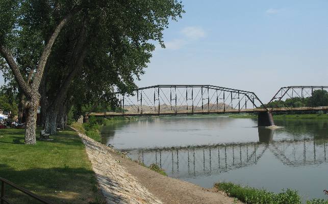
The Missouri River as it looks from the historic levee in downtown Fort Benton.
While the river looks so serene in this picture things were different on main street in Fort Benton. Fort Benton has the reputation of having the "Bloodiest Block in the West". One person on the scene wrote the following: "It's a tough town, walk in the center of the street and keep your mouth shut." Gunslingers walked this street; few earned a reputation, but more earned eternity here than in of the other fabled western towns. Indians were fair game. Their corpses dumped into the river started war and massacre. Mose Solomon, saloon owner, eliminated two customers on the corner. There was a saying that goes something like this ----- and several others gunned down on this street "won't be missed." Poker was played with six-guns atop the table, and females from the brothels were as tough as the men. Madame Moustache (don't you just love that name) brandished Colts to halt the landing of a steamboat carrying smallpox. Saloons and "houses" stayed open all night. The block was lined with barrooms, cathouses and gambling dens -- so lawless it had to be circled by a cavalry troop so a U.S. Marshal could serve warrants on five of its residents.
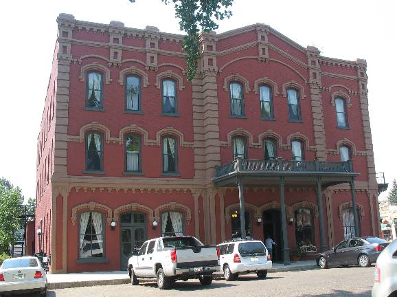
One story we learned about when we visited the Grand Union Hotel was the story about an incident that took place in the hotel. It seems some rowdy individuals were in the bar area (on the bottom floor of the hotel) when one man said that he could ride his horse up the stairs to the top floor. From this beginning a bet was on. Then next thing anyone knows is the front doors of the hotel were opened and this fellow comes galloping into the lobby on his horse and headed up the stairs. The bar tender grabbed his shot gun and shot the man riding the horse as he arrived at the first landing on the stairs. This is THE Grand Union Hotel that opened in 1882. It was Fort Benton's pride, a haven of relaxation in a boisterous frontier town at the head of navigation on the Missouri. Total cost of the finest hostelry between Seattle and the Twin Cities was $200,000. The name echoes the reconciliation following the great Civil War in which many guests participated, in blue and gray. Steamboats blew for their landings and great cattle herds crossed the Missouri within sight and sound of its patrons. Army officers, Canadian Mounties, miners, trappers, freighters, river captains, stockmen, missionaries, Indian agents and road agents rubbed shoulders in the Grand Union's lobby, supped in its spacious dining room and adjourned to its well-stocked bar for the relaxation due a frontiersman at a weary journey's end.
I took this picture of Joyce next to a giant cottonwood tree located on the river outside the Grand Union Hotel in downtown Fort Benton.
When steamboats plied the Missouri in the 1800s, Fort Benton was the world's innermost port; waterfalls just up the river prevented further navigation. During the 30-years that steamboats regularly docked here the town bustled with the activity of merchants, traders, cowboys, American Indians, miners and adventurers. Today, Fort Benton's restored main street honors its rich and rowdy history.
The Fort Benton Levee (on the left side of the river) was a busy place back in the days following the Civil War. For example, on June 14, 1869 nine sternwheelers were moored along the levee unloading whiskey, gold pans, salt, bacon, boots and miners. Ox teams hauled the freight from the levee to far-away points. Wells Fargo coaches took miners to Helena for $25, fights with the Blackfoot Indians were free. Six hundred of these "mountain-boats" (since they came nearly to the Rockies) docked at Fort Benton from 1859 to 1890. These steamboats supplied the U.S. Calvary, the Indians they hunted, Canadian Mounties, and whiskey-runners. Benton merchants were plumb impartial about business. They purveyed their goods from posts at Fort Whoop-Up, Qu'Appelle, Last Chance Gulch (modern day Helena) and other places with just ordinary names. One spring before the first boat arrived, tobacco sweepings were sold to eager residents at a buck a pipefull
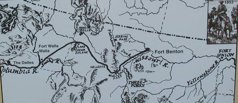
Sometimes historically important things are overlooked in text books, in my opinion the MULLAN ROAD, is one of those places.
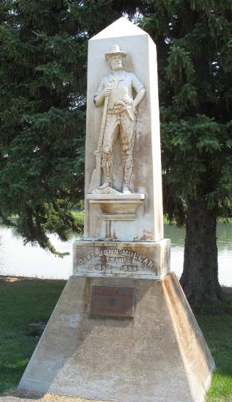
The Mullan Road connected Fort Benton on the Missouri River with Fort Walla Walla on the Columbia River. It was the first federal highway in the Northwest. Covered wagons, stage coaches and freighters used this route to the gold bonanzas in the mountains of Montana and Idaho. Branches led to Helena, Bannack and Virginia City. The main road continued on west through Missoula and up the Clark's Fork to Spokane, before turning south through the Palouse to the Columbia. Note that the Mullan Wagon Road is the connecting link that President Jefferson envisioned when he sent Lewis and Clark west with the Corps of Discovery in 1804. At a fraction of the cost of an interstate turnoff, Captain John Mullan constructed the 624-mile wagon road from 1855 to 1862 that linked Fort Benton to the head of navigation on the Columbia. Indian wars slowed him somewhat, but Mullan opened his route to travel in 1860, years ahead of the transcontinental railroads. The Mullan Road began right at the levee here in Fort Benton and ended at Fort Walla Walla. A tourist heading for Spokane retraces hundreds of those miles, but no longer contends with Blackfoot Indians to insure his interest in the surroundings. The road's history has faded into forgotten lore, but it was a highway to empire, the fastest land-water route across the continent in its day. Travelers took 47 days on the road, but boarded steamboats at either end where comfort and pleasure promised a safe arrival at either terminus. This statue, along the levee in downtown Fort Benton, is honoring Captain John Mullan.
I thought it appropriate to include this map of the Mullen Road so that you can more easily understand the significance of this road in the early history and settlement of this segment of the North American Continent. Do understand that the Mullen Road traversed the Rocky Mountains and the Continental Divide as it connected these two river routes. The Mullan Road wasn't the only historic road with its genesis in Fort Benton. The Whoop-up Trail was just as important to to the early history of Canada. The Whoop-up Trail was a wagon road from Fort Benton to Canada. Whiskey traders carried supplies north and brought buffalo robes south to Fort Benton for transport down river by steamboat. Later the Whoop-up Trail supplied the Northwest Mounted Police at Fort Macleod. From 1869 to 1883 most supplies came up river by boat, then by wagon to Canadian settlements as far north as Calgary and Edmonton. The trail ran up the Teton, by the Knees, via Baking Powder Flats to Shelby, then across the Canadian border and the Milk River to Fort Macleod and Lethbridge.
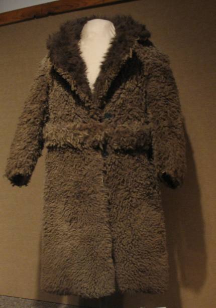
This is one of the buffalo robes that were transported south from Canada to be transported down river by steamboat to St. Louis.
The Whoop-up Trail from Fort Benton to Fort Macleod was the main artery of commerce in the 1869-1883 era. Twenty yoke of oxen was a team and each team hauled three of the heavy freight wagons loaded with trade goods, calico and whiskey. They returned to Fort Benton with hides for the St. Louis market. Until the closing of the river trade this road was the source of supply for the Royal Canadian Mounted Police, the boundary survey and the Canadian Pacific Railway. The resourceful, fearless plainsmen and bullwhackers gathered at this end of their hazardous journey. The name Whoop-up Trail came from the activities associated with arriving in Fort Benton and other towns after a long journey over the Trail leading from Fort Macloud, Canada.
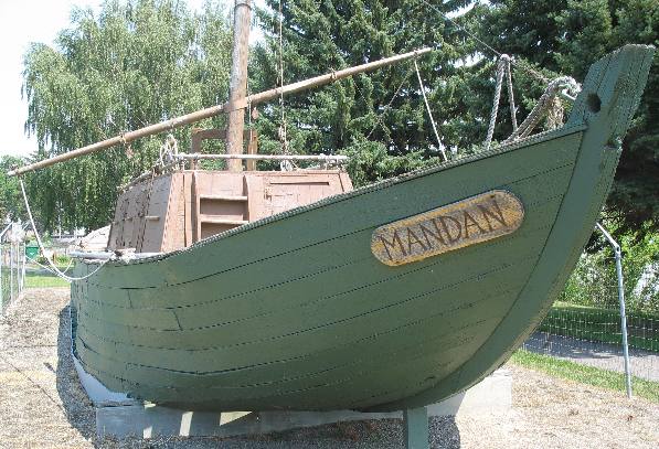
The Keelboat Mandan is on display on the levee in downtown Fort Benton. This particular keelboat replica was built for Guthrie's movie The Big Sky. Keelboats antedated steamboats and used every kind of power - chiefly man - except steam. Propelling them was no idle pastime. The usual method was to set long ash poles in the river bottom, toe the cleated walk and push hard, bow to stern. Crews also stumbled along the bank at the end of a cable. Favoring breezes thankfully indicated a sail. The keelboat speed record, a brisk 1,100 miles in 61 days, was set in 1811 by a select crew of Manuel Lisa, an impatient character. South Dakota winds chased his vessel clear around the Great Bend below for 75 miles in a long day. In the enclosed cabin keelboats carried beads, whiskey and other goods traded for beaver and buffalo robes at Indian posts along the Missouri.
As the demand for buffalo hides replaced beaver pelts and the gold rush began, a settlement outside the post walls catered to a new kind of traffic. Fort Benton's mile-long levee, the world's innermost water port, docked fifty steamboats a season bringing prospectors, traders, homesteaders and merchandise to this northwest gateway and carried buffalo hides, bullion and passengers back to "the States". Fort Benton's merchant princes sent traders laden with rifles and whiskey into Canada to lure Indian peoples away from trade with Hudson's Bay Company. The lawlessness that resulted brought the newly-created North West Mounted Police into present-day Alberta and Saskatchewan. As the Mounties worked to curtail the whiskey and gun trade, they brought the same Fort Benton companies goods back to western Canada to supply all the needs of their posts. Convoys of high-sided freight wagons drawn by teams of oxen carried tons of food, supplies, mail, and treaty rations to Canada and returned with buffalo bones and hides, furs, wool, pelts and coal. Fort Benton's glory was mighty but short-lived. The railroad replaced the river in the 1880s. Just as quickly as the trade routes sprang up they were replaced.
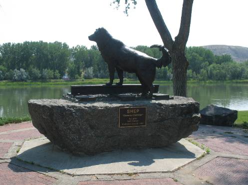
The story of Shep and Shep's vigil is a heart warming story. In August 1936 a casket containing a sheepherder's body was loaded on a baggage car headed East for burial. A dog, of collie strain, watched with anxious eyes. He was to be there to meet every train year after year. Conductor Ed Shields pieced the dog's story together, linking Shep with the body shipped that August day. With the real story known, Shep became famous. Many well-intentioned offers to adopt Shep. Over 50 sheepherders offered to give Shep a home, but he would not leave his vigil. Friends knew Shep's sole aim in life was to keep his vigil. Shep, not a young dog at the time of his masters death, met every train for the next 5 1/2 years! Shep died one January day in 1942 when he slipped on the tracks before an incoming train. His passing was mourned by all who knew his story. Townsfolk buried the faithful Shep January 14, 1942 on a bluff overlooking the depot. His funeral was attended by hundreds, and school was dismissed so the children could attend. The Fort Benton Boy Scout Troop #47 acted as pallbearers and another scout sounded taps at the grave side. Great Northern employees erected a profile monument of Shep and built a concrete marker in his honor. The station installed a spotlight which was turned on the grave each night so passengers on evening trains could see the monument. Fifty-two years later Fort Benton residents and fans of Shep from around the world erected a heroic size bronze statue of Shep that is located on the banks of the Missouri River in downtown Fort Benton.
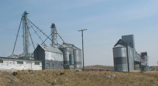
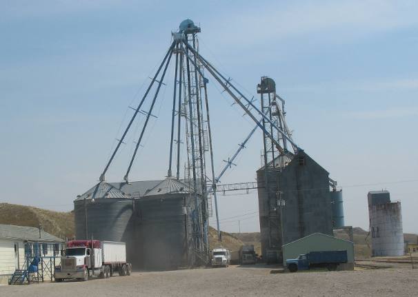
After that wonderful experience in Fort Benton it was time to return to Great Falls and our motorhome. On the way out of Fort Benton we spotted activity at this group of grain elevators.
Trucks full of grain were stopping on the scale that the truck on the left is on then upon dumping their load of grain they returned to the scales. The driver jumps out of his rig and goes inside for an all important piece of paper. The two tractor trailer rigs you see between the grain elevators are both unloading grain.
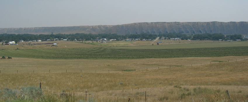
For a change this farmer is growing hay in the bottomland where he has access to a pivot irrigation system. The houses you see on the left side of this picture are on the western outskirts of Fort Benton. The line of trees you see are growing along the banks of the Missouri River.
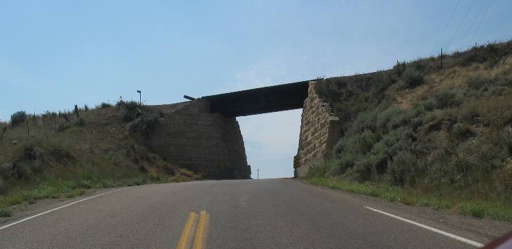
Like so many Railroad overpasses in this area a two lane road is squeezed into one lane to pass underneath the RR. Usually, there will be a sign saying which direction has right of way.
This field of grain has been harvested and the only thing remaining is these rows of straw.
We stopped for a few minutes to watch this pair of harvesters making short work of this grain field.
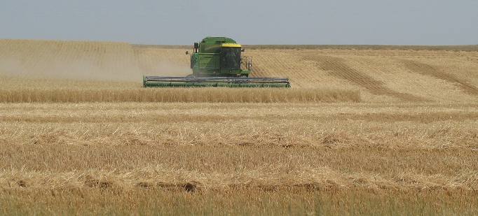
Men operating those harvesters keep them on the move, relentlessly on the move. You can tell when a harvester is operating over the horizon by the cloud of dust they create.
Up one side and down the other relentlessly gobbling up ripe heads of grain in a huge swath.
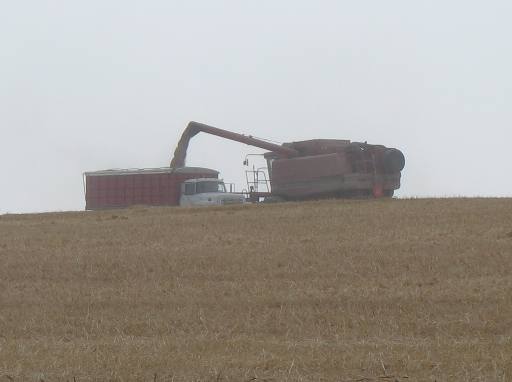
When the harvester is full of grain they deposit their load of grain into awaiting trucks that deliver the harvested grain to area grain elevators.
If you look closely you can see the spiral shape of the grain as it flows out the end of that snout.
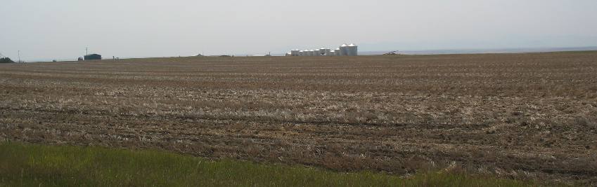
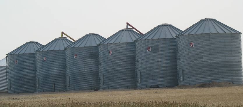
Some of the grain will be stored in bins like these, located on the farmer's property while other grain will be transported to large grain elevators located in every small town along the local RR tracks.
And this final picture of a harvester unloading grain into a transport vehicle. Our next stop will be the motorhome
Until next time remember how good life is. Mike & Joyce Hendrix
|
| ||

| |||