Camas PrairieThe Camas Prairie
June 23, & 24 2007. We stayed at Mountain View MH & RV Park in Grangeville. It is a Passport America Park $14 for FHU, cable & wifi. It isn't a resort but we had shade and a nice large site in a clean environment 208-983-2328. If you are looking for a "Resort" Christmas tree RV-Resort is on US 95 less than a mile from the middle of town. Then on the 24th we moved the motorhome to Lewiston about 65-miles to the northwest where we stayed at the Clearwater River Casino & RV-Resort. The RV-Park is an old KOA and in bad shape. We would not recommend it. There are several parks in Clarkston, Washington that would be much more preferable. Our cell phones work in Washington. If you have Verizon or Alltel and possibly Sprint you are probably going to be roaming in most parts of western Idaho where they are serviced by an "off-brand" cell service that does not have contracts with the big carriers like Verizon and Alltel. Things return to normal in Washington. TV is bad to non-existant at Clearwater River Casino & Resort. I could go on but won't.
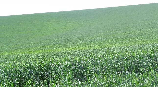
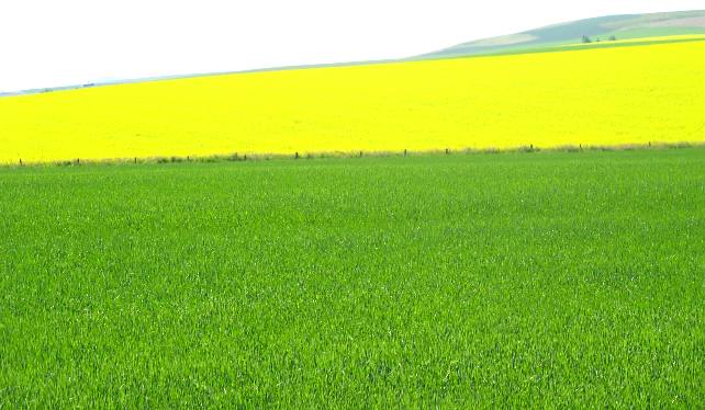
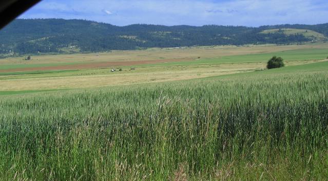
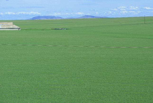
Grain field in the Camas Prairie of western Idaho that stretches to the horizon
The present day Camas Prairie has many different faces, all wonderfully beautiful. Grain fields stretch to the horizon as do bean fields and canola.
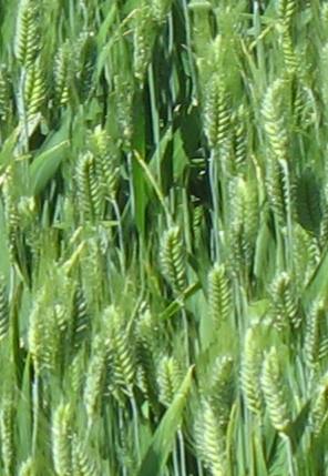
This is probably oats. If you recognize what type of grain this is please let me know.
The Camas Prairie is a plateau of approximately 200,000 acres lying between the Clearwater and Snake rivers. Over 100 years of cultivation has changed the rolling landscape into a patchwork quilt of wheat, canola, oat and hay fields. In late May the few small unplowed areas still burst forth with the familiar blue camas blooms.
Grain of some kind growing on the Camas Prairie
This is a close-up, can you tell if it is wheat or oats?
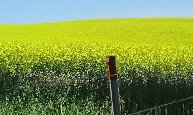
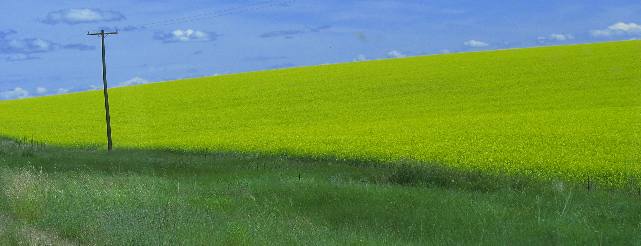
We were mesmerized by the brilliant yellow canola fields
In addition to bright green grain fields yellow canola fields dot the matrix of fields throughout the Camas Prairie.
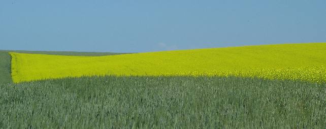
Contrasting patterns beteen grain & canola fields
Contrasting patters abound throughout the Camas Prairie.
This is what Central Idaho looks like now but it hasn't always looked this way. During the decade following the discovery of gold in California in 1848, restless brands of prospectors, lured by the hope of sudden wealth, arrived in what is now north-central Idaho. In 1860, gold was discovered on Canal Gulch of Oro Fino Creek, a tributary of the Clearwater River. Soon after, prospectors traveling over the Nez Perce Trail discovered gold in Elk City a few miles from the southeast corner of the Camas Prairie. A small band of gold-seekers also struck it rich in the remote Florence basin. Between September 1861 and October 1874, gold shipments out of Florence added up to $13,000,000. When gold was discovered in Idaho, a few Chinese filtered into mining camps and communities like Grangeville to run restaurants and laundries, and doctor the miners with their country cures, Others settled in the warm canyons along the Salmon River where they cultivated fruits and vegetables and raised hogs and chickens to sell to the miners. After completion of the Central Pacific Railroad, more Chinese flocked to Idaho when laws allowed them to buy exhausted mining claims. Historians estimate that in the 1870s, the Chinese accounted for 28% of Idaho's population. The December 1904 edition of The Standard reported that Chinese miners shipped more than $5,000,000 in gold from Florence alone.
Sometimes stories need to be told and the one about Polly Bemis is one of those stories. Sometimes heart warming stories are about small people and Polly is one of those. She was only broomstick high and beautiful -- a dance hall girl. Her real name was Lau Nathoy, but in the mining town of Warrens, Idaho, they called her Polly. She was born in China and when she was 14, her father sold her for some seed and pieces of gold. She was smuggled into Portland and sold for $2,500. At nineteen, so the story goes, Polly was the pot of a poker game between her Chinese master, Hong King, and Charley Bemis, a prominent saloon keeper and mayor of Warrens. Berris brought her a boarding house and in 1890, when he was shot in the face in a fracas, Polly saved Charley's life with her crochet hook. She cleaned out his wound and nursed him back to health. In 1894, Charley Bemis married Polly; she was 41 and he was 46. Four years later, they bought acreage and moved to the Salmon River. In 1922, the Bemi's house burned down and Charley died a few months later. Their neighbors, Pete Klinkhammer and Charley Shepp, built a new house for Polly so she could continue to live near her beloved river. On a visit to Grangeville in 1923, Polly experienced the wonders of a move, an automobile, and a train. She lived on the river for ten more years, but in 1933, at age 81, illness forced her to return to Grangeville where she died and was buried. In June of 1987, Polly's wish was fulfilled when her remains were moved back to her place on the river, now known as ---------- the Salmon River Resort.
Canola and grain an amazing contrast in color on the Camas Prairie
That yellow canola field looks as if someone has painted the field. It is just that spectacular.
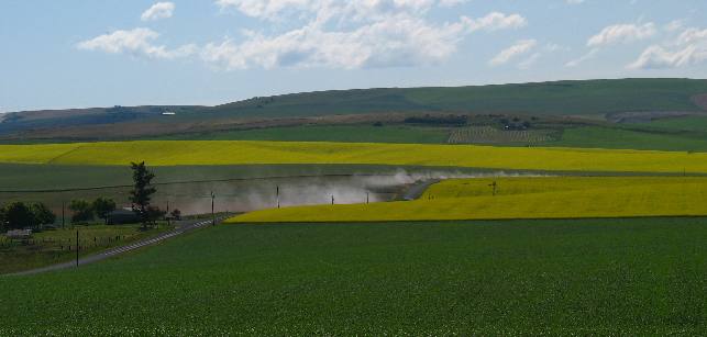
Canola fields justapoxed against a grain field on the Camas Prairie south of Nezperce, Idaho
In addition to the contrasting fields this one has two vehicles driving down dirt roads leaving a trail of dust.
Grangeville, on the south end of the Camas Prairie is the county seat of 8,500 square mile (5.4 million acres) Idaho County. Grangeville is also the largest community on the Camas Prairie, where the population and elevation meet at about 3,500. The area boast a fascinating history, complete with Nez Perce culture, Chinese lore and tales of gold rushes and the Old West. This is BIG country. Idaho County is the nation's third largest county. Bigger than the states of Rhode Island, Connecticut and Delaware combined Idaho County has a small population of just over 16,000. One thing I can tell you is those 16,000 residents sure do add to the nation's bread basket as can be seen by our pictures.
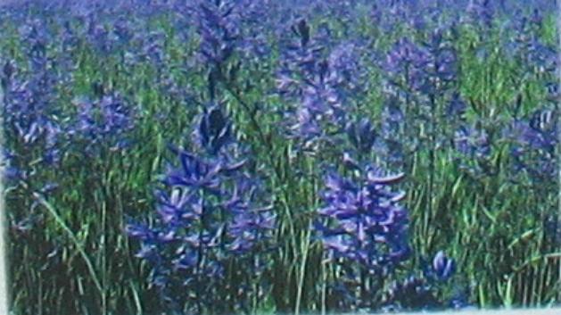
The Camas Prairie was named for Camas lilies like these
Camas, the plant the Camas Valley was named for are not nearly what they used to be. Camas bulbs, which grow about 4 to 6 inches beneath the ground, are harvested in a centuries-old tradition by Nez Perce women in August and early September. The bulbs are then painstakingly prepared and stored. As you can imagine the once abundant camas fields have been destroyed by ranching and farming operations.
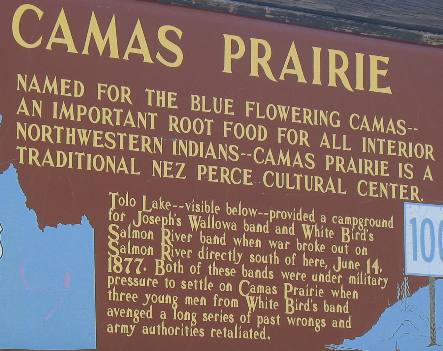
Camas Prairie Kiosk with history information
Tolo Lake, you will recall is the lake named for Tolo the Indian woman who rode 28-miles on horseback one night to warn her friends that an attack on them was being planned. The lake was subsequently named for her.
Southwestern corner of the Camas Prairie in western Idaho
Tolo Lake is a small lake somewhere out there on the prairie in this picture of the southern corner of the Camas Prairie in western Idaho.
We pulled out of Grangeville on the southern end of the Camas Prairie in the motorhome and headed northwest to Lewiston about 65 miles away. This drive will take us across the middle of the Camas Prairie.
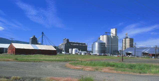
Grain elevators on the outskirts of Grangeville on the southern side of the Camas Prairie
Leaving Grangeville we see a familiar sight that will be with us all day and that is grain processing and storage facilities like this one.
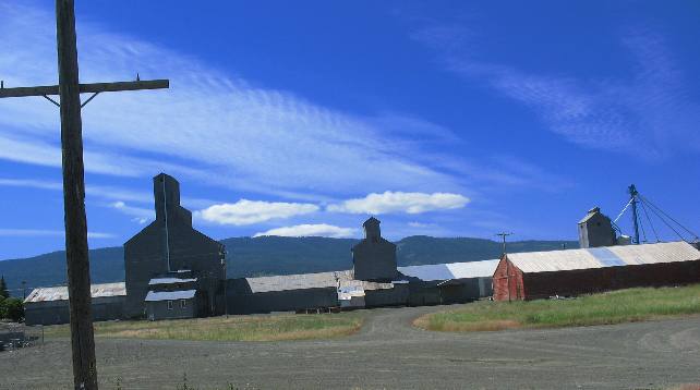
Grain elevators on the outskirts of Grangeville on the southern side of the Camas Prairie
Grain storage facilities come in all sizes and shapes.
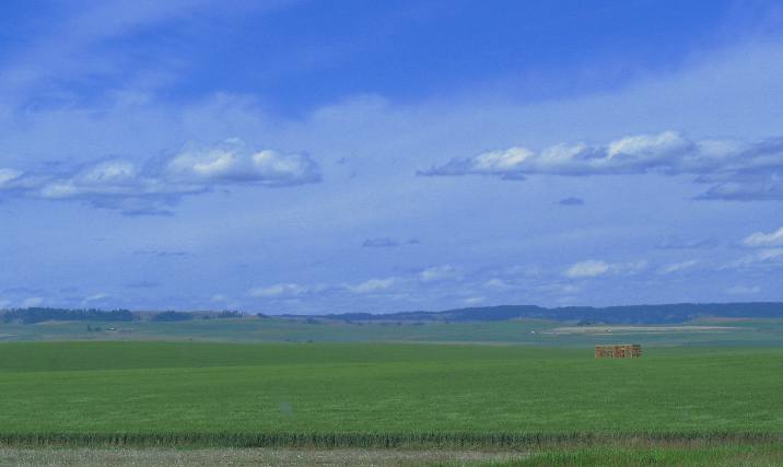
Grain field stretching to the horizon in the Camas Valley of western Idaho west of Nezperce
In a few months this grain field will be filling those storage facilities.
Grain field stretching to the horizon in the Camas Valley of western Idaho west of Nezperce
How many storage facilities will it take to hold the grain produced in this field? Like many in the Camas Prairie this field stretches to the horizon.
Canola field stretching to the horizon in the Camas Valley of western Idaho west of Nezperce
Some plant grain while others plant canola. Both look like they will produce bountiful crops.
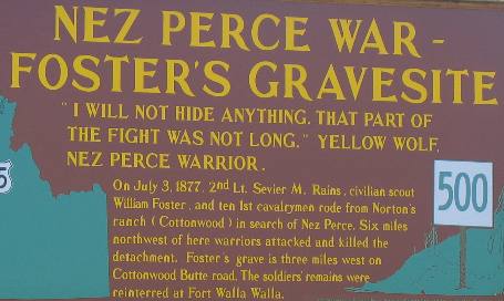
Foster's Gravesite from the Nez Perce War -- 1877
Every few miles we stop to read the history kiosk provided by the state of Idaho.
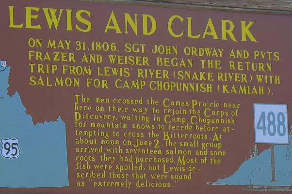
Kiosk commemorating Lewis & Clarks Corps of Discovery visit to the Camas Prairie in western Idaho
We have read this story in our Lewis and Clark books on many occasions.
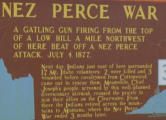
Nez Perce War of 1877
Lawyer's Canyon in the Camas Valley of western Idaho
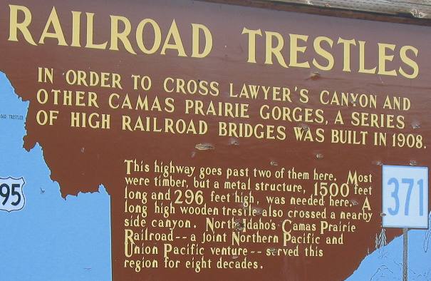
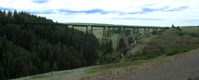
Railroad Trestles across Lawyer's Canyon on the Camas Prairie
Railroad Trestles across Lawyer's Canyon on the Camas Prairie
This is the railroad trestle across Lawyer's Canyon.
Bright yellow canola field in the Camas Valley of western Idaho
This canola field adds color to the patchwork of fields.
Bright yellow canola field in the Camas Valley of western Idaho
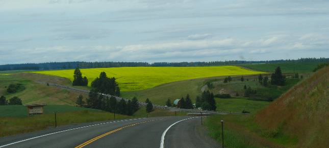
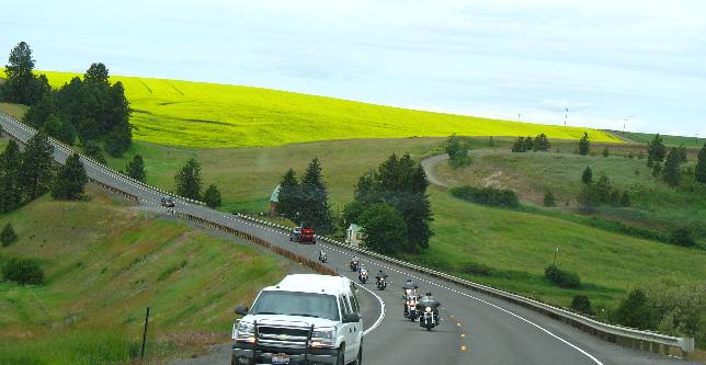
The further north we go on the Camas Prairie the more hilly the prairie gets. Canola still adds to the color while hay fields and grain fields add to the contrast. Motorcyclist love the beauty of this drive.
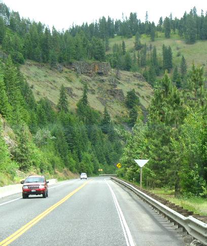
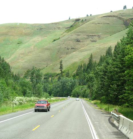
US-95 dropping into Lewiston from the northwestern part of the Camas Prairie in western Idaho
And finally we move out of the prairie but the highway continues to drop toward Lewiston.
Lewiston, is located on the lowest elevation in the state of Idaho. You might have surmised that since it sits at the confluence of two great rivers the Snake and Clearwater. If you don't know the Snake River turns west from its northern course and heads into Washington where it will shortly meet the mighty Columbia and continue its journey to the Pacific.
US-95 dropping into Lewiston from the northwestern part of the Camas Prairie in western Idaho
Rivers and highways are all falling on there way to Lewiston. It seems like we coasted all the way from Winchester to Lewiston. Winchester Lake State Park is at an elevation of 4040' while Lewiston is at 800'. As you can the drop is over 3,000' in around 25-miles. Dropping 3,000' in 25-miles means that the vehicle does not need much if any gas and most of the effort is going to be involved in controlling the downhill speed.
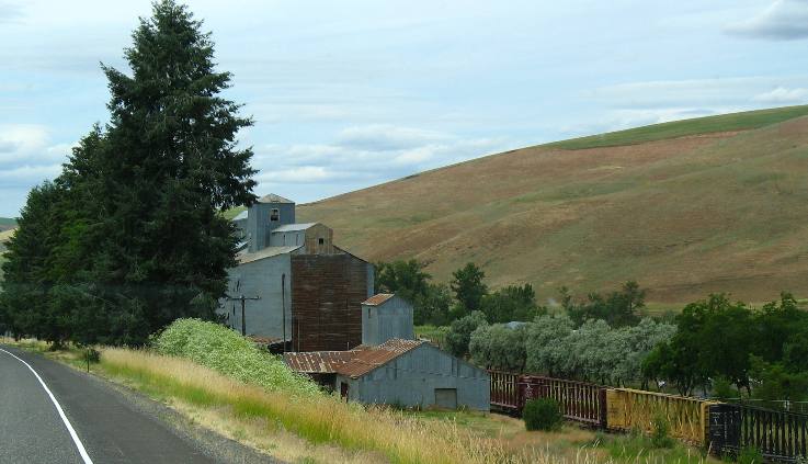
Grain elevator along US-95 between the Camas Prairie and Lewiston in western Idaho
I don't understand it but grain loading and storage facilities continue to pop up generally where railroad lines run close to the highway.
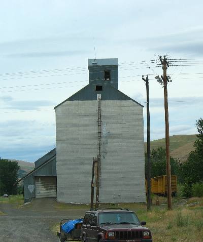
Grain elevator along US-95 between the Camas Prairie and Lewiston in western Idaho
At this point we are 5 to 10 miles from what I would consider the Camas Prairie where the bulk of the grain is grown but these grain storage and handling facilities continue to dot the landscape.
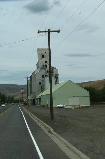
Grain elevator along US-95 between the Camas Prairie and Lewiston in western Idaho
We are almost to Lewiston when we spot this large grain storage facility.
Click here for more Idaho travellogsUntil next time remember how good life is.
More Idaho AdventuresSome of our Miscellaneous Subjects ** More 2007 Travel Adventures
Mike & Joyce Hendrix
Mike & Joyce Hendrix who we are We hope you liked this page. If you do you might be interested in some of our other Travel Adventures: Mike & Joyce Hendrix's home page Travel Adventures by Year ** Travel Adventures by State ** Plants ** Marine-Boats ** Geology ** Exciting Drives ** Cute Signs ** RV Subjects ** Miscellaneous Subjects
We would love to hear from you......just put "info" in the place of "FAKE" in this address: FAKE@travellogs.us Until next time remember how good life is.
|
|
||

|
|||
|
|
|||
|
|
|||
|
|