Sawtooth Valley south of Stanley, Idaho
Today we are driving SR 75 south of Stanley,
Idaho through the Sawtooth Valley to the summit of Galena
Pass.
June 15, 2007
Our motorhome is in Garrity
RV-Park in Nampa 10-miles west of Boise.
It was $21 per-night for FHU & Cable while every place else in
the area seemed to start at $26 and rapidly go up. Garrity was just
fine. It was clean, well managed, the sites were close but we were
not there and didn't go outside except when heading to and from the
automobile. There was a good number of permanent or long term in the
campground but they were being managed properly thus were no problem.
We would stay at Garrity again but those that like to spend the day
and evening under the awning sipping cool ones might rather be in
one of the other area parks. N43° 35.245' W116° 31.592'
Our motorhome may be back in Nampa at Garrity RV-Park but we got
a motel room in Stanley
last night. We were on a very long scenic drive yesterday and decided
that we could better experience what we wanted to see by staying in
a motel overnight. We found ourselves in Stanley
still wanting to check out the scenic drive along the Salmon
River north on SR 75 out of Stanley
plus we wanted to drive to the pass on the Scenic Drive south on SR
75. Bottom line, we needed to spend the night in Stanley
if we wanted to have time to experience these areas.
We got up early Friday morning, it was the only way to accomplish
all the things we wanted to do today. We headed south on SR 75 through
the beautiful Sawtooth Valley toward Galena
Pass & Sun
Valley.
We aren't planning to go all the way into Sun
Valley. Our plan is to climb Galena
Pass to the summit between Stanley
and Sun
Valley then turn around and return to Stanley.
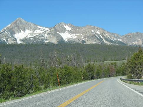
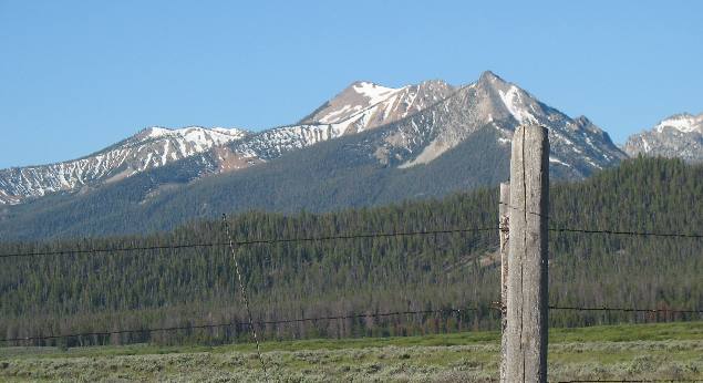
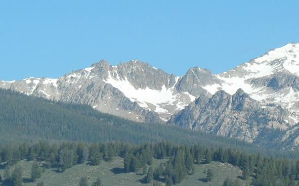
For those of you interested in geology there are two rather small
circues visible in this picture. Cirques
are the bowl shaped indentions you see that are filled with snow.
You can learn more about cirques
here: Cirques
Sawtooth Valley and Mountains from Stanley,
Idaho
As I recall this picture, of the Sawtooth
Mountains, was taken from Lower Stanley
along the bank of the Salmon
River.
To early explorers the Sawtooth
Mountains resembled a huge saw lying on its back. The jagged
"teeth" were carved by glaciers ages ago.
Take a good look at the Salmon
River flowing through this "crack" in the mountains
surrounding Stanley.
Twenty five miles south of here this river has its beginning as snow
melt from Sawtooth Mountain glaciers.
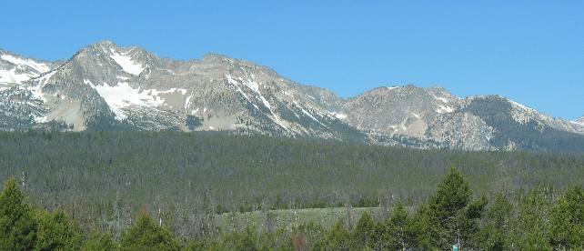
Sawtooth Valley south of Stanley,
Idaho on SR-75
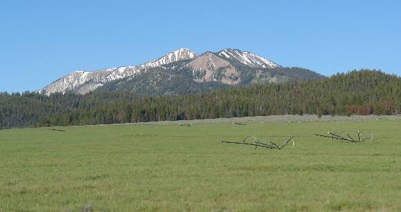
The drive south of Stanley
through the Sawtooth
Valley on SR-75 is one beautiful drive and Joyce is trying
her best to capture it.
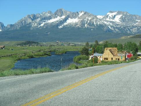
Vienna, Idaho in the Sawtooth
Valley
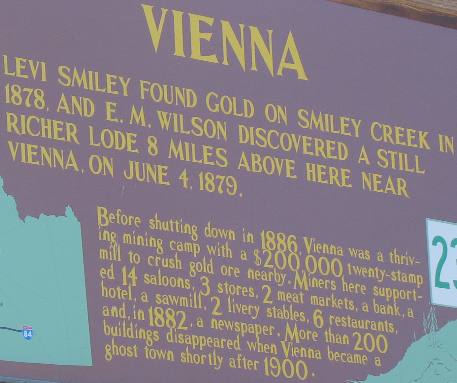
The Sawtooth Valley along the budding Salmon
River was the site of several gold strikes in the late 1800s.
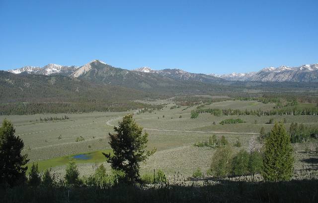
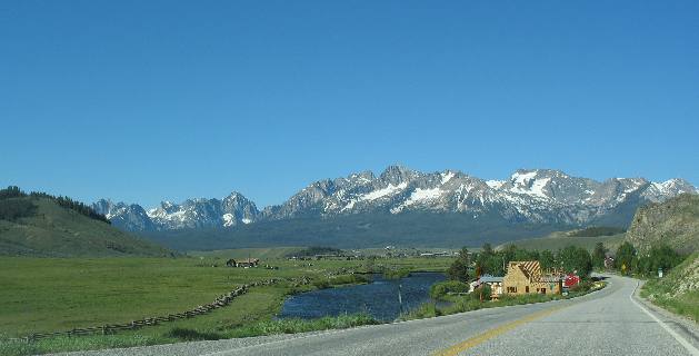
Here is the Sawtooth
Valley looking north from Galean
Pass. The headwaters of the Salmon
River form in this valley. The Salmon
River begins as a small stream seen in the left side of this
picture. It winds 420 miles across Idaho
before flowing into the Snake River south of Lewiston very near the
"three corners area " of Washington,
Oregon and Idaho.
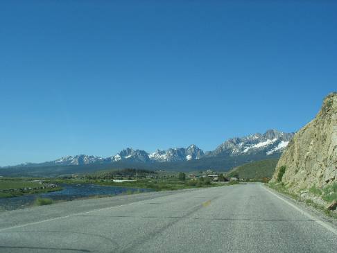
If you are interested, you can spot the small stream that develops
into the Salmon
River as it flows through the Sawtooth Valley by looking in
the left center of this picture. In the grass flat area locate the
thin strip of trees. Once you have located the thin strip of trees
in the grass look closely along the trees and you will see a dark
green line of vegetation. That dark green vegetation is growing along
the bank of the small stream that develops into the Salmon
River.
The Salmon
River was first "discovered" by white men, in 1805
when Lewis and Clark passed this way on their epic journey. Later
it was explored, with great difficulty, by fur traders and prospectors.
The Salmon
drains a vast tangle of rugged mountains and deep canyons in central
Idaho. Before 1950, boats
could not ascend the main canyon, so the Salmon
got the name "river of no return". Large tracts of untamed
wilderness are still found in the Salmon
River Mountains.
The Salmon
River has also affected the destiny of Idaho.
Because of the river's rugged canyons, the Lewis and Clark expedition
of 1805 turned back, calling the Salmon
River, "The River of No Return."
To us the Sawtooth Valley around Stanley
is one of the most beautiful places in the United States. Everywhere
you look delivers stunning beauty.
Note the glacial circues filled with snow high in the Sawtooth Mountains.
Cirques
are the bowl shaped areas filled with snow. To learn more about cirques
click here: Cirques.
Until next time remember how good life is.
Mike & Joyce Hendrix

Mike
& Joyce Hendrix who we are
We hope you liked this page. If you do you might be interested in
some of our other Travel Adventures:
Mike & Joyce Hendrix's home
page
Travel Adventures
by Year ** Travel
Adventures by State ** Plants
** Marine-Boats
** Geology ** Exciting
Drives ** Cute Signs
** RV
Subjects ** Miscellaneous
Subjects
We would love to hear from you......just put "info" in
the place of "FAKE" in this address: FAKE@travellogs.us
Until next time remember how good life is.
