Ponderosa Pine Scenic Byway
The Ponderosa
Pine Scenic Byway and Idaho
City are two things you what to do when in the Boise
area of Idaho.
June 14, 2007.
We are staying at Garrity
RV-Park in Nampa 10-miles west of Boise.
It was $21 per-night for FHU & Cable while every place else in
the area seemed to start at $26 and rapidly go up. Garrity was just
fine. It was clean, well managed, the sites were close but we were
not there and didn't go outside except when heading to and from the
automobile. There was a good number of permanent or long term in the
campground but they were being managed properly thus were no problem.
We would stay at Garrity again but those that like to spend the day
and evening under the awning sipping cool ones might rather be in
one of the other area parks. N43° 35.245' W116° 31.592'
Ponderosa Pine Scenic Byway, Idaho
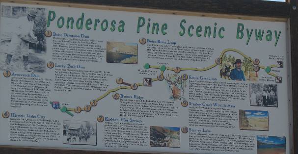
From Nampa we headed south through Boise
on I-84 to exit 57 where we got on SR-21 also known as the Ponderosa
Pine Scenic Byway. The Ponderosa Pine Scenic Byway starts
at exit 57 on I-84 near Boise.
From exit 57 Ponderosa
Pine Scenic Byway proceeds to Idaho
City, Lowman
and finally Stanley.
Diversion Dam on the Boise River
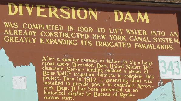
This dam was one of several dams located on the Boise River along
our route.
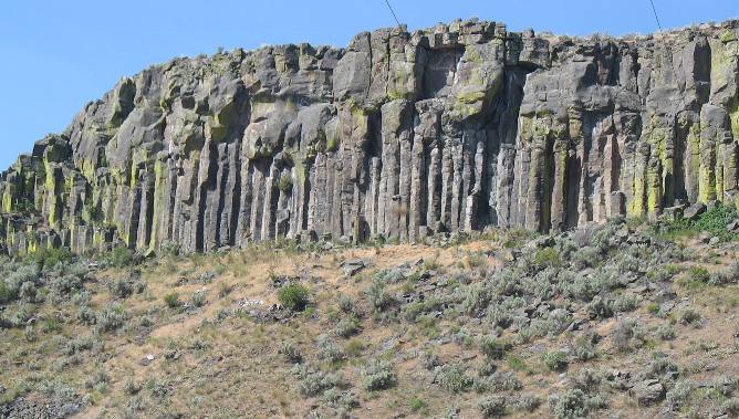
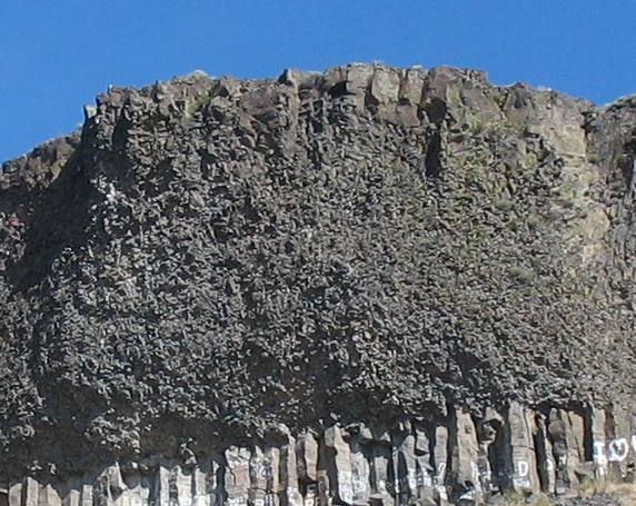
Basalt
cliffs like these rim the Boise River and reservoir.
You should be recognizing columnar
jointed basalt by now. Check out this basalt
flow and you can clearly see the columnar
joints in the basalt.
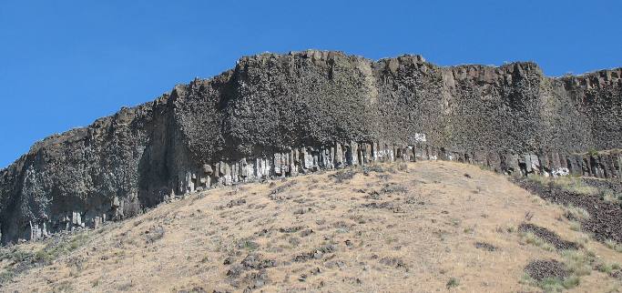
This basalt had an odd look to it. That is columnar
jointed basalt on the bottom but what is that odd looking
basalt
on top of the columnar
joints?
Peculiar basalt
deposit
This is a close up of particular section of basalt.
I do not know what caused that, do you? Has it got a name? Surely
this type of basalt
is discussed in geology text books.
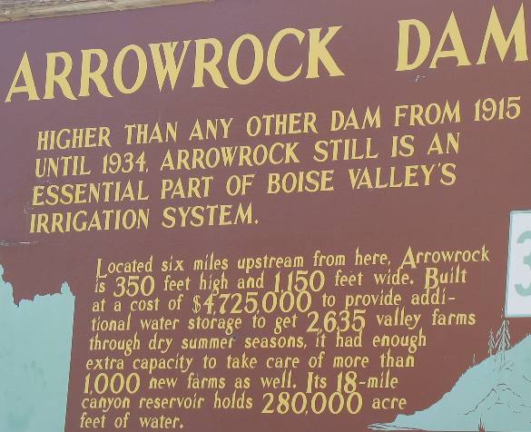
Arrowrock Dam on the Boise River along the Ponderosa Pine Scenic
Byway of Idaho
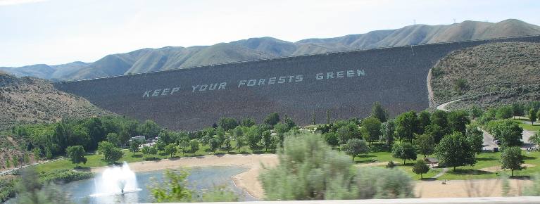
This is Arrowrock Dam complete with a sand beach for public use.
Arrowrock Dam on the Boise River along the Ponderosa
Pine Scenic Byway of Idaho
Idaho's J. Marion
More: Idaho City and the
Ponderosa Pine Scenic Byway
Idaho City and the Ponderosa
Pine Scenic Byway
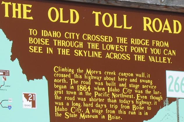
In 1862 Idaho City
was the largest city in the Pacific northwest after gold was discovered.
More gold was mined in Idaho
City that in all of Alaska.
With that many people and that much activity a lot of supplies had
to be brought here in wagons. Remember that 1864 is before the Transcontinental
Rail Road was completed in 1869.
Syringa, the state flower of Idaho
as seen on Ponderosa Pine Scenic Byway
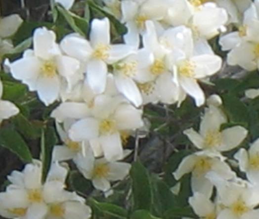
This pretty flower is syringa the state flower of Idaho.
We see it at elevations around 4,000 feet.
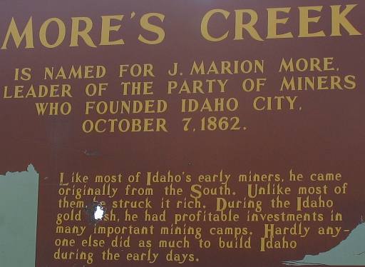
Grimes' Creek & George Grimes: Idaho
City and the Ponderosa Pine Scenic Byway
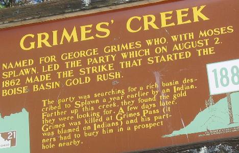
The individual that discovered the gold that made Idaho
City never got to spend it.
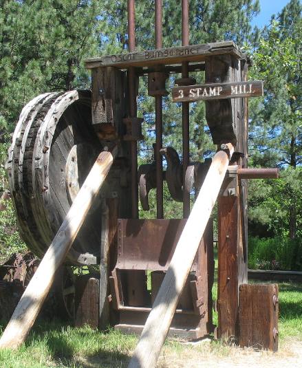
This stamp mill was on display at the local museum. Stamp mills were
used to crush ore bearing rock containing gold. This was the method
of releasing gold from the quartz rock. For those mechanically inclined
individuals ----- a steam engine would provide power that would turn
that large wheel by a large leather belt. The wheel turned those large
cams on the horizontal shaft. The cams lifted the two vertical rods
that have 1,000 pound stamps on the bottom. The cam lifted those stamps
about 18-inches then rotated out of the way and the stamp fell on
the gold bearing rock crushing it to almost dust.
One can only imagine the noise and dust created in this operation.
Many stamp mills had 20 to 30 stamps thus the noise and dust would
be multiplied accordingly.
Mores Creek Summit on Ponderosa Pine Scenic Byway in Idaho
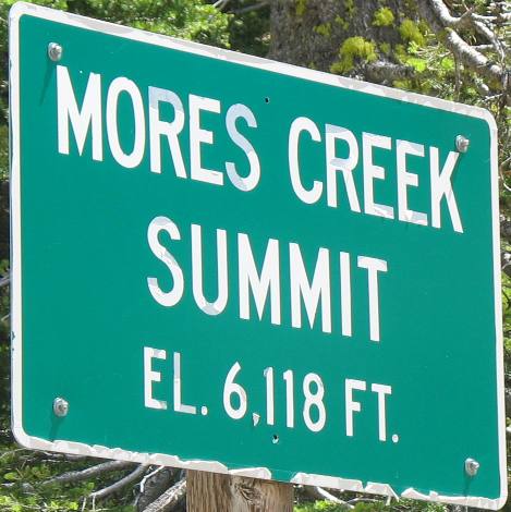
Mores Creek Summit is on SR-21 the Ponderosa
Pine Scenic Byway north of Iowa
City. I included this sign to let RV'ers know what kind of
elevations are on SR-21.
Roadcut on the Ponderosa Pine Scenic Byway
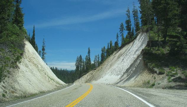
This roadcut was somewhere on the Ponderosa
Pine Scenic Byway. It looks like volcanic
ash to me but I am not sure. If it was volcanic
ash there was a LOT of it as this roadcut is over 30' deep
and there is no indication we are at the bottom of the ash.
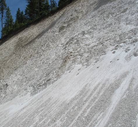
This looks like volcanic
ash to me but I sure would like to hear from a geologist.
Until next time remember how good life is.
Mike & Joyce Hendrix

Mike
& Joyce Hendrix who we are
We hope you liked this page. If you do you might be interested in
some of our other Travel Adventures:
Mike & Joyce Hendrix's home
page
Travel Adventures
by Year ** Travel
Adventures by State ** Plants
** Marine-Boats
** Geology ** Exciting
Drives ** Cute Signs
** RV
Subjects ** Miscellaneous
Subjects
We would love to hear from you......just put "info" in
the place of "FAKE" in this address: FAKE@travellogs.us
Until next time remember how good life is.
