Places Visited: Wyoming: Fort Laramie, Guernsey and Casper (North Platte River, US-26 and I-25) July 7 & 8 2006: Casper East RV-Park Casper, Wyoming. Casper East RV-Park is a mom and pop operation without a mom & pop! N42° 51.357' W106° 17.338' $24 for water & 30-amps central sewage. They feature gravel interior roads & pads: This is NOT a destination campground by any means however, it certainly looks much better than the Fort Casper RV-Park which is nothing but a crowded dusty dirt parking lot.
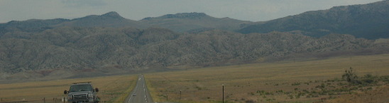
Joyce had Wind River Canyon picked as our outing for today. We are in Casper, Wyoming and have to travel from Casper to Shoshoni on US-20/26 to get there. Locals Consider the drive between Casper and Shoshoni as the "longest drive in the state." Low, rolling, sagebrush-covered hills, not much to see on the horizon, and the sheer distance from "civilization" contributes to this sentiment. But the geology can be interesting for those not accoustomed to this terrain. Looking for subtle changes in the landscape keeps us interested.
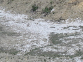
Between Casper and Powder River we are able to spot occasional outcrops of shale then as the elevation drops to Powder River we are able to discern spots of white caliche. Caliche soils occur in low areas where water stands in winter and evaporates in summer, leaving a residue of salts and calcium carbonate.
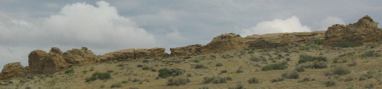
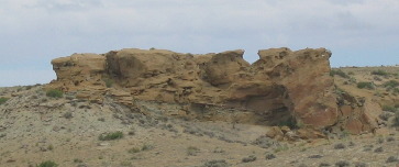
"Hoodoos," strongly eroded outcrops that take on human-like forms appear a few miles east of Shoshoni.
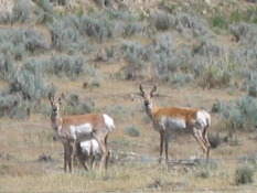
Sagebush is the predominant vegation and pronghorn antilope are the predominant animal visible on that long lonely drive from Casper to Shoshoni.
Wind River Canyon is one of those special places that isn't ballahoed in promotional literature for some reason. The Canyon offers one of the best exposed and complete sections of sedimentary rocks anywhere.
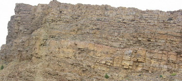
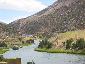
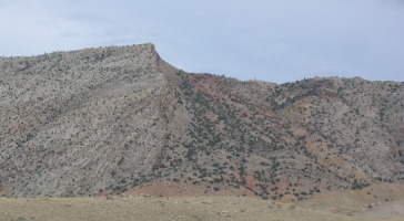
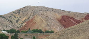
Over 100-million years of sedimentary rocks are exposed in the canyon. This sandstone formation has weathered with several large bolder becoming dislodged.
Here are some bolders that came dislodged from the cliffs above and actually rolled into the Wind River. While the picture on the right is of a magnificent cliff exposing 100-million years of geological history.
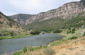
The canyon has been cut/created by the Wind River through the Owl Creek Mountains. In one of those hard to explain things as the Wind River emerges from the north end of the canyon, it becomes the Bighorn River and flows north through the Bighorn Basin and the northern Bighorn Mountains, eventually emptying into the Yellowstone River in Montana. The Wind River not only changes names along it's course it flows north. I would say that is a pretty unique river. It would have seemed, at least to me that the Wind River would flow east like the North Platte that we had been following, but no the Wind River runs north. It really doesn't seem logical. The two rivers are only 100-miles apart in this part of Wyoming. Geologist say the river had its birth during a time when this area was relatively flat created by erosion of the mountains with that deposition in the basins. It was also a very dry period. Streams established their courses at this time, totally indifferent to the fact that they were flowing over buried uplifts of Precambrian rock and strata (Precambrian is very hard rock consisting of granite, genesis and schist). In the last 2-million years the climate has become weter and the Rocky Mountains were uplifted; this caused the streams to downcut their channels. If a section of channel was over a buried uplift, like the Owl Creek Range, the river cut into the underlying rocks and eventually formed a canyon. In summary this seemingly illogical course was due to the fact that the Wind Rivers Course was determined before the present landscape of ranges and basins existed.
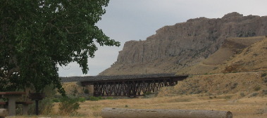
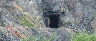
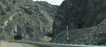
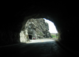
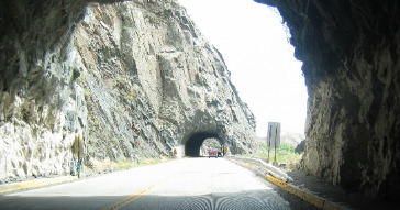
The Wind River cutting through the extremely hard Precambrian rock in Wind River Canyon is exactly what we saw in the Royal Gorge in Colorado where the Arkansas River did the same thing. The Wind River cut such a narrow canyon through this hard rock that there wasn't enough room for railroad tracks and a highway. The only way for engineers to follow the river with trains and highways was a series of tunnels. The highway has three tunnels in a row. On the otherside of a river train tracks are darting in and out of a series of tunnels. In the picture on the right that is a railroad tunnel on the other side of the Wind River, while the other two tunnels are for the highway on this side of the river.
While the vertical cliffs through Wind River Canyon are not as spectacular as the cut through Royal Gorge it is more spectacular in other ways. Joyce snapped this series of pictures as we darted from one tunnel to the other.
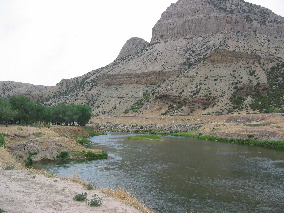
It is easy not to know anything at all about Wind River Canyon because it is not advertised. However, when in this part of the world it is certainly something that you should take time to visit. Wind River Canyon is located between Shoshone and Thermopolis, Wyoming on US-20.
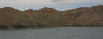
Today we are entering from Shoshone at the south end of the north/south trending canyon. The first thing you see as you turn north out of Shoshone is the Owl Mountains stretching east and west across the horizon.
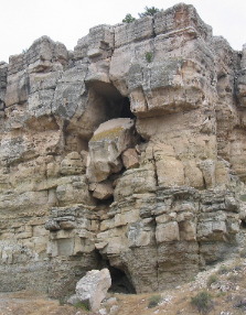
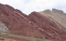
The closer we get to the mouth of the canyon we see stark evidence of major faulting. Huge sections of sedimentary rock are thrust skyward at 45-degree angles. What is unusual about this faulting is while looking in the same place you can see those angles going in bizzar directions--as in they were nor all going the same way and at the same angle.
This is a region of complex faulting. Geologist call this "roll-over" or arching. This occurs when fault lines don't run perpendicular to the earth's crust. If you can imagine cutting a section of apple then squeezing the apple to force that cut section to rise out of it's original place. That is what has taken place here except there were many slices/cuts/faults that were pushed up or squeezed down and they can be seen with the naked eye. What geologist ramble on an on about in books can be seen here. One only need to stop and look at the variety of angles on the uplifted strata of sedimentary rock to understand that some phenomenal force caused this.
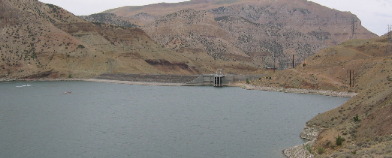
Boisen Dam across the Wind River has created a huge reservoir in this otherwise arid region. Our eyes have a hard time concentrating on the faulting and esposed sedimentary rocks while at the same time trying to ignore this beautiful lake in the middle of an otherwise desert.
Boisen State Park is at the entrance to the canyon so we stopped there and paid our $4 entrance fee to drive around and look at the facilities while getting a closer look at the reservoir.
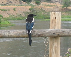
Joyce snapped this picture of a magpie while we were stopped in one of the campgrounds of the Boisen State Park scattered along the banks of the Wind River in the Canyon.
This was an awsome drive for us. We came through the Wind River Canyon in our motorhome back in 2002 and realized how special this canyon was. Since then we have wanted to return when we had more time to explore and savor the sights. Until next time remember how good life is. Mike & Joyce Hendrix
|
| ||

| |||