Mike & Joyces Travel logs

Home ** 2005 Travel Logs**


Places Visited:
California: Yosemite National Park & Mariposa

Sunday, June 5: High Sierra RV-Park Oakhurst, California: $25.20 FHU-50amp. Paved interior roads with grass/gravel sites. Free WIFI N37° 19.887' W119° 38.810' 559-683-7662

We moved the motorhome to Oakhurst today. Oakhurst is the gateway into Yosemite via the southern gate. It was only a 70-mile drive so we had plenty of time to chill in our new RV-Park.

Monday, June 6: High Sierra RV-Park Oakhurst, California: $25.20 FHU-50amp. Paved interior roads with grass/gravel sites. Free WIFI N37° 19.887' W119° 38.810' 559-683-7662

We got up early and headed into Yosemite via CA-41.

Oakhurst is the small town located just outside the south entrance to Yosemite at about 2,500' elevation. We were on CA-41 when we arrived in Oakhurst yesterday and continue east on it today as we head into Yosemite. CA-41 is much like the entrance into Kings Canyon in that it climbs and climbs with 6% grades then relentlessly climbs some more. The good thing is there are no hairpin turns so vehicles with adequate horsepower can easily run 50 to 60 mph.


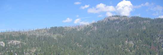
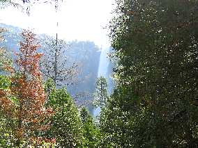
As we gain altitude on the way into Yosemite the mountains become larger and are more rounded.


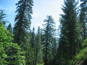
While Oakhurst is at around 2,500' elevation CA-41 takes us to just over 6,000' somewhere in Yosemite before the road drops into the spectacular Yosemite Valley. The road into Yosemite Valley is a fun ride but again no switchbacks that I can remember.

Note the road cut across the face of that bulge of volcanic rock.
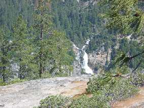
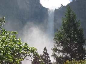


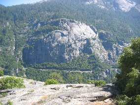
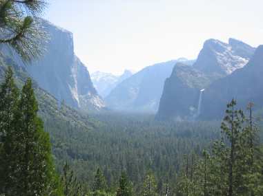
Yosemite Valley is beautiful as you might expect. A lot of people are in the park to view the waterfalls. As we all know California had a LOT of rain this winter with this part of California (the Sierras) receiving their precipitation in the form of snow. Tioga Pass that crosses the Sierras into Nevada via Yosemite Park is not open because of snow. Someone told us that Tioga Pass had 13' of snow on it and so much snow was on the side of the roads that the snow removal equipment couldn't get the highway snow over that. They were saying it would be early July before Tioga Pass was cleared of snow and opened.
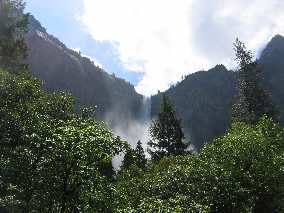
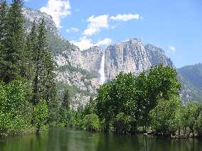


All we had to do was look up when driving through this beautiful valley to see waterfalls.
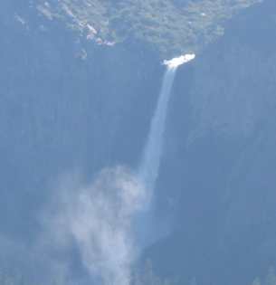
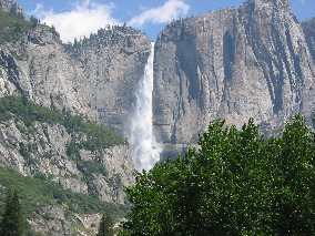


Everywhere we looked there was another spectacular waterfall.
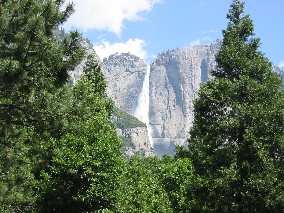


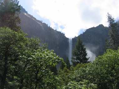
There is just something about waterfalls. They draw your eyes and attention to them. There is something mysterious and magical about them.
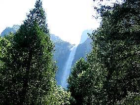


Anyway you express it there is a LOT of water flowing off the top of this canyon and it is all snow melt.


While the waterfalls are spectacular so are the vertical walls of volcanic rock. Actually, this rock was molten magma that pushed its way----entruded into the existing sedimentary rocks where it cooled. The much softer sedimentary rock is long gone--eroded and washed away to be deposited in the San Joaquin Valley.
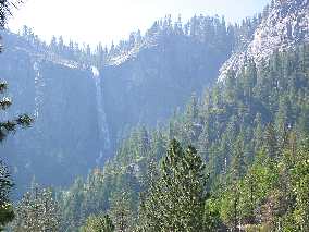


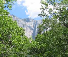
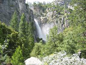
Some of the waterfalls are visible from long away while others are almost hidden.


The water flowing in these pics is from one of the huge waterfalls. As you can see the water is rushing around trees obviously way outside its normal channel. The tremendous volume of water flowing off the rim in those spectacular waterfalls is creating new channels to flow in.


More waterfalls seeking a route to the Merced River.


The raging torrets eventually reach the Merced River that flows out of Yosemite.


From purple flowers to tunnels Yosemite was visual overload.


To top off the Yosemite experience Joyce got to stroll through the gift shop where I snapped this pic of her with a bear.


We did the normal tourist things while in the valley like walk in the meadow and along the swollen river. We stopped and gazed up at all the waterfalls, and there are a lot of them this year with all the snow melt. We were told by people that frequent Yosemite that they had never seen so much water pouring over the falls. They were all amazed, while we thought it was normal.


Yosemite Valley actually has the three tallest waterfalls in North America dropping into it: Yosemite Falls at 2,425', Sentinel Fall at 2,000' and Ribbon fall at 1,612'. It also contains the largest rock monolith in the United States in El Capitan at 3,593'. Tioga Pass at 9,945' is the highest road in the Sierra Nevada Mountains.

When walking in the meadows we can see grass and debris hanging in trees a long way from and above the river providing evidence that earlier this year even more water was flowing through here.

We ate lunch at the lodge and rode the free bus around. Actually, the park bus is a good way to get around in Yosemite Valley.

We exited the park on CA-140 that wends its way into Mariposa where we connected with CA-49 (the 49'er route) that took us south back to Oakhurst. CA-140 didn't have any hairpin turns either but it did have some "kickin" 9% grades as it first climbs out of Yosemite Canyon then literally falls to Mariposa and the San Joaquin Valley. It seemed like all I had to do was downshift and hold on as we flew down the grade from Yosemite. There were some curves in the road but most could be negotiated at 60-mph. If your RV has the HORSEPOWER there is no reason you can't drive it along CA-140 into Yosemite.

Compared to the south entrance to Sequoia on CA-198 out of Three Rivers both of the roads into Yosemite are "pieces of cake".

Tuesday, June 7: High Sierra RV-Park Oakhurst, California: $25.20 FHU-50amp. Paved interior roads with grass/gravel sites. Free WIFI N37° 19.887' W119° 38.810' 559-683-7662

We visited Mariposa today. Mariposa is an old historic town very important in the early history of California. Colonel John Freemont is the "father" of Mariposa. You will recall that Colonel Freemont is the Army Officer that led exploratory missions into California in search of routes over the Sierra Mountains. Kit Carson was his guide on at least 2 of Freemont's 4 missions. John Freemont ran on the Republican ticket for President but was beaten by James Buchanan who served between 1857 and 1861.

John Freemont was a big name in Mariposa back in the 1850's during the height of the gold rush. On one of his scouting missions to California he had given $3,000 to a man with instructions for him to purchase land for him. When Freemont returned to California to settle his land in the early 1950's he found that the man had not purchased the land as instructed but had instead purchased 44,000 acres south of the Merced River. Anyway, John was furious that the man had not purchased the agricultural land as instructed -------- that is he was furious until gold was found in the area. Freemont imported Mexican miners who made him a millionaire within a few short years. By now you have put two and two together and realized that the man had purchased property for Freemont that contained the "Mother Lode".

In Mariposa today we visited the California State Mining and Mineral Museum housing the State's official collection and as such a premier attraction. It is located at the Mariposa Fairgrounds on CA-49 one mile south of town.

The Mariposa Fair Grounds is also an RV-Park. There isn't a phone number that I could find. The RV-sites operated strictly on the "honor" system. They have sites with hookups available. All you do is drive into the parking lot at the Fair Grounds and look for the sign, then fill out the card and put your money in the envelope provided and drop it in the box. The sign says some one will be by to check. You know as much as I do now.

The next place we visited was the Mariposa Museum and History Center located in town. This was a really good museum for a small town. It chronicled Mariposa's grand historic role as the site of the first hard rock mine in California, on John C. Fremont's property.

The museum featured hand written letters written home by miners and others to explain how things were in the 1850's. Those reaching this area made the trip on sailing ships from the east coast to the coast of Panama where they disembarked and walked across the mountains to the Pacific where they caught another ship up to San Diego or San Francisco. One of the most detailed letters was that of Fremont's wife who wrote home to describe her journey across the mountains of Panama from the Atlantic to Pacific Oceans.

Until next week just remember how good life is.

Mike & Joyce Hendrix


Home ** 2005 Travel Logs